Getting There: At Superior, take Diamond Road east past the Town Pump Gas Station for 6 miles; passing the Bark mill and the Magone Ranches to the end of the pavement where the road changes to Trout Creek Road (#250). Continue up Trout Creek Road (~19 miles) until you top out on Hoodoo Pass on the Idaho/Montana border.
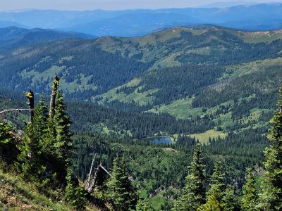
Take the stateline trail #738 for 4.5 miles to the split where the left fork heads down to the saddle between Pearl and Dalton Lake. Stay right on #738 as it passes above Dalton Lake and heads up to 7,250 feet and a view of the Middle and Upper Trio’s. The trail then starts heading the nearly 2 miles down to Goose Lake (5,800 ft), this is the first available water since Hoodoo Pass except for some possible snowbanks along the way.
The total distance to Goose Lake is a solid 7 miles. Even though the distance is a bit over 7 miles, it is a hard route as there are significant elevation changes across the stateline trail, not a lot of shade and water is not readily available. If it is a hot day, the hike can be hard.

Getting There: At Superior, take Diamond Road east past the Town Pump Gas Station for 6 miles; passing the Bark mill and the Magone Ranches to the end of the pavement where the road changes to Trout Creek Road (#250). Continue up Trout Creek Road (~14 miles) to the Heart Lake Trailhead. There is a vault toilet and parking for over 20 vehicles. Trail #171 takes off on the far side of the parking area. The trail wanders through the bottoms, gradually climbing up the valley for 2+ miles. Then the trail turns up the hill and climbs much steeper for the next 3/4 mile to Heart Lake.
Cross the outlet onto trail #175 and continue around Heart Lake to the far end. The trail continues to climb and switchback up the hill for 1 mile to Pearl Lake. Continue around Pearl Lake to the low saddle overlooking Dalton Lake. Turn right and follow the trail up the ridge to stateline trail #738.
There is a little bit of a break above Dalton Lake but then the trail continues to climb to the high point of 7,250 ft. From there you lose almost 1,500 ft over nearly 2 miles to Goose Lake. This route is a bit longer than the Hoodoo Pass route with water available at least to Pearl Lake but you are climbing steadily (2,600 ft) for 6 miles. Kind of a pick your poison when hiking from the Trout Creek side. The hike from Heart Lake trailhead to the high point is a bit of a grind if completing it in a day with a full pack.

Getting There: Take the Fish Creek Exit on I-90 and proceed up Fish Creek Road #343, then the right fork on road #7750 (Iowa State Research Center) that ends at the Clearwater Crossing in 6.75 miles. The clearwater crossing has a small campground (3 sites), 2 vault toilets and a Forest Service Guard Station. Take trail #103 that takes off to the right of the Guard Station on an old road. After a mile the trail splits with trail #103 heading up hill to the right. Straight Creek trail #99 stays straight along the creek. Stay on this trail for about 12 miles passing the Greenwood cabins, crossing French Creek and past Fletcher Gulch over that span.
There is plenty of water along almost the entire length of the trail, with just the last mile or so to Goose Lake being dry. The North Fork trail is not too bad, it is well maintained and is a gradual climb up the valley until the last couple miles from Fletcher Gulch. Of the trails starting at or near the Clearwater Crossing, it is usually in the best condition.
Getting There: If you don’t mind taking a bit longer drive. At Superior, take Diamond Road east past the Town Pump Gas Station for 6 miles; passing the Bark mill and the Magone Ranches to the end of the pavement where the road changes to Trout Creek Road (#250). Continue up Trout Creek Road (~19 miles) until you top out on Hoodoo Pass on the Idaho/Montana border. Continue up Trout Creek Road (~19 miles) until you top out on Hoodoo Pass on the Idaho/Montana border. Continue on Road #250 into Idaho for about 11 miles. About a tenth (0.1) of a mile before crossing the Middle Fork of the Clearwater River, road #250 crosses Long Creek and stays left of the Clearwater River. If you cross the river and get to the Cedars Campground, you have gone too far.
Stay on road #250 for another half (.5) mile then stay left on road #295 up Lake Creek for about 4.5 miles. There will be a picnic area / trailhead with a vault toilet at the intersection. Take the left fork road #5450 for about 1 mile and park at the turnaround at the gate.
 The first mile of the trail (#414) is the continuation of the road, the road eventually narrows down to a trail. The trail rises gently with the only extended grade in the 1/2 mile around the Steep Creek crossing and last mile after passing through the meadows. The trail through the meadows can be a bit difficult to follow, but the trail runs fairly straight across each meadow. I found in 2024 that there was a lot more brush than in the past, a lot of waist and occasional head high brush. If it has recently rained or is raining, it will be a wet hike (it was). The distance to Goose Lake is about 5.75 miles. There is plenty of water (~ 6 small crossings) on this trail so there is no need to carry water for the entire route as you do on some sections the State Line Trail.
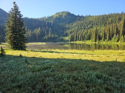
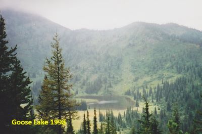
At the Lake: Goose Lake is just a pond that is frequented by Moose, Elk, Deer, and Wolves among many others; but fish are not on the list. There are 2 main camping sites around the lake. This is a major horse camp during the late summer and fall so things are kind of beaten up by the horse and mule traffic. The better camping site and water are over by the inlet on the far side of the lake, the water at the outlet is warm and does not taste clean. It passes muster if filtered but not the best for taste. However, this is a good basecamp for day trips into the Trios or climbing Crater Mountain.