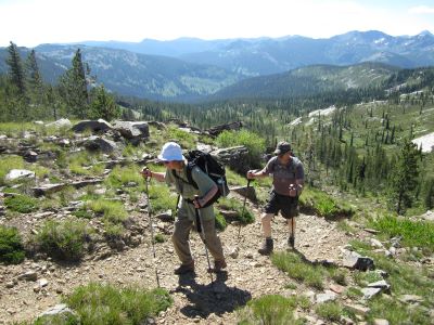
What to Expect:  This 10.5 mile section of Stateline Trail #738 has a number of well placed water sources along its route with 3.5 miles being the longest stretch of dry trail. There are three lakes that the stateline trail goes by along with several springs, so you don't have to load up on water like some of the other sections of the trail. Extended steep grades on the trail are absent, but there are several long moderate grades that you will feel by the end of the day. Views are excellent, but not quite as spectacular as the previous section, with an opportunity to easily make the summit of Admiral Peak; the farther South along the route the better the views.
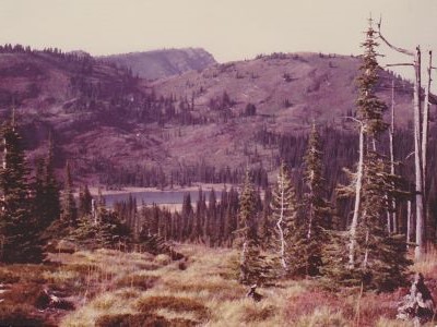
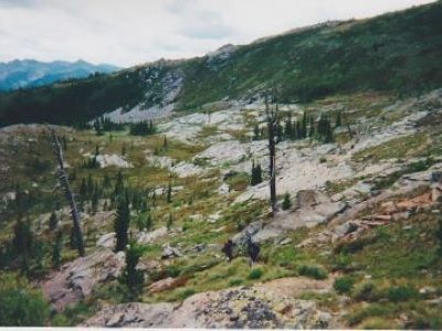
There are 6 lakes along the route; Vann, Mud, Kelly (ID), North Cedar Log, South Cedar Log and Kid Lake (ID). Vann, Mud and Kid Lakes are right on the stateline trail with the Cedar Log & Kelly Lakes to far for just filtering water, but are excellent camping options. The stretch between Fish and Kid Lakes are lightly used, so there is a good chance of having the trail to yourself. This is a deceptively hard section of the state line trail. The trail is actually pretty good most of the way, but there are just some long stretches of uphill that can wear you down. The stretch between Vann Lake and Mud Lake is my least traveled section with just a couple trips over the years and I don't have 1 good picture over that 3.5 miles.
Getting There - Fish Lake: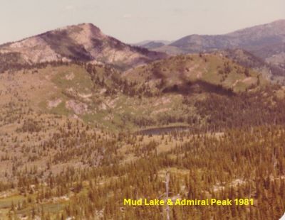 I have provided a descriptions to the trailhead on past sections as a road intersects the stateline, but in this instance I will just reference the individual descriptions for Fish Lake. They contain trailhead and trail descriptions from several directions; so see the Fish Lake Page for more detail.
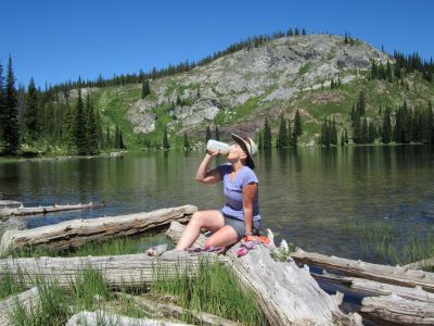
Trail #738 Description North to South: Starting where stateline trail #738 comes down to Fish Lake at the outhouse and connects with trail #419 from the Lake Creek trailhead; follow the road around to the east end of Fish Lake. Near the end of the road, look for a trail to the left; it was signed in 2025. Motorized use is disallowed on the trail. It is about a mile up to the saddle where the trail splits with the right fork, trail #490, heading to Bruin Hill and eventually the Kelly Creek drainage. There isn't a sign exactly at the fork, but there are signs just 100 feet or less along each trail. Stay left on the state line trail #738 as it continues to climb very moderately to a second saddle before dropping into Vann Lake; also called W Fk Fish Creek Lake 1 by the MT Fish & Game. The trail from Fish Lake to this saddle has a very easy grade and is in good condition. The trail then cuts down across the hill thru an old fire where it switchbacks down to Vann Lake and crosses the outlet. Vann Lake contains 10+ inch Cutthroat Trout and the fishing in 2025 was good. The campsite at the lake is flat and has lots of room. There is no water past Vann Lake until until you get to Mud Lake so water up here.
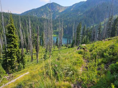
From Vann Lake (6,100 ft) you will climb to 7,125 ft over the next 2 miles as you as you work around Admiral Peak. It is kind of a slog, not overly steep but a constant up that eventually makes your legs heavy. The summit of Admiral Peak is less than 200 feet above you as the trail tops out on the ridge, so...... The trail then heads down the ridgetop for 1.5 miles to the intersection with trail #104 coming from Mud and the North Cedar Log Lake. It is just a short jaunt, < 1/4 mi to your left to Mud Lake if you need water or your trailmate needs a swim. The water is similar to the stale taste of Goose Lake but usable. There is also another small spring a couple hundred yards down trail #104 from Mud Lake that is better. The North (Little) Cedar Log Lake is less than a mile down the hill, with a good unsigned trail all the way to the lake.
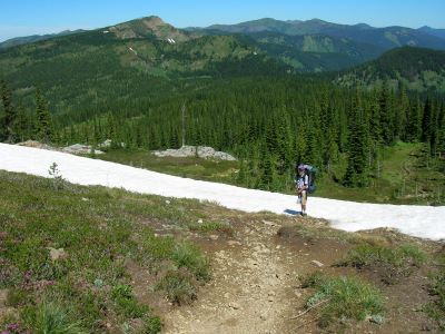
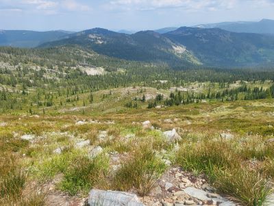
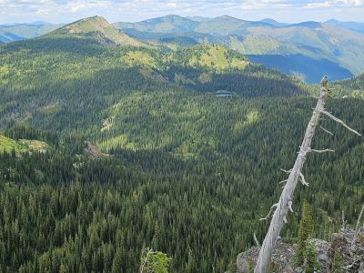
Trail #738 heads moderately uphill to the right for a mile gaining 700 feet before topping out at almost 7,000 feet on a rocky saddle, 7.0 miles into the route. Early in the summer, there is a nice snowbank on the north side of the saddle, as pictured in background. Take an extended break here as this is one of the better views along the stateline as you are looking down into the expansive Kelly Creek drainage with Shale Mountain and Rhodes Peak in the distance; you may even see some elk down below. Continue down the rocky trail for 1 mile to Kid Lake, passing by another spring along the way. At Kid Lake, trail #567 comes up from Kelly Creek at the outlet. Kid Lake can have some good fishing as I have caught a couple 14-16 inches in the past. Cross the outlet and follow the trail/old road up the hillside merging with the trail/road from the South (Big) Cedar Log Lake in 1/2 mile. When I was really young in the 1960’s, people could drive all the way into Kid Lake and also to above the South (big) Cedar Log Lake, as there was an old mining claim at the end.
Follow this old road as it sidehills across the mountain and then crosses over into Montana. This section can be quite hot as there are lots of rock slides along the old road to reflect the heat back to you. After crossing back into Montana, about a third of a mile down the hill, there will be a good spring that comes out of the rocks with some nice shade. Continue down the hill merging with the road to the mine visible along the hillside. The trailhead is just past the gate for a total of 10.5 miles.
The trailhead is dry, but there is a nice stream a quarter mile down the road where I usually hide some refreshments. Dispite the great access that this trailhead provides, I really hate it. It's not the rough & brushy road into the trailhead but the fact it has to be one of the buggiest places along the stateline (outside of Hub & Goose Lakes). After a long day on the trail a person would like to relax for a bit at the vehicle, but every time the biting flies and mosquitos are just atrocious; the later in the day the worse they are. Anymore, I just throw the pack in back and head out to the gate to change clothes and relax a bit there.
Getting There: Take the Fish Creek Exit on I-90 and proceed up Fish Creek Road #343, for approximately 16 miles and turn right on Surveyor Creek Road #7734 for 12 miles to the Schley Mountain Trailhead. This is a rough 12 miles, especially the portion past the Surveyor Lake trailhead at 8.5 miles. The Schley Mountain Trailhead has several places to camp and park along with a vault toilet. This trailhead and campground are dry, so bring plenty of water if camping. This is not the actual end of the road. The gate is only open from when the snow is off until August 31; the gate is not open over Labor Day weekend.
The road behind the gate is designated by the Forest Service as a non-maintained road.  The Forest Service does not maintain or brush out this road. If you are the first one through the gate in the summer, then expect to saw out the downed trees from the winter storms if you want to drive the 3 miles to the end of the road and the old trailhead. The road is pretty good until you reach the 2 switchbacks, and the road gets decidedly worse from there for the last 1.25 mile. Pullouts are a bit scarce so someone may have to back up a ways when meeting another vehicle. The trailhead has plenty of room for parking and several camping sites; the ridge trail from Schley Mountain connects back to the road.
Trail #738 Description South to North: Head down the road past the gate for 1/3 mile, then take the left fork up the hill. The right fork heads over to a mining claim nestled under the stateline. About a 1/2 mile will bring you to a nice spring and some shade. From here it's 1/4 mile up to the stateline, a total of 1 mile. Once on the state line stay on the main road / trail that heads north with great views of the Kelly Creek drainage, Shale Mountain, Leo Lake area and Rhodes Peak. The road / trail will split again at the 2-mile mark with the right fork continuing to the South (Big) Cedar Log Lake and the left down to Kid Lake.
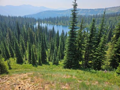
Head down to Kid Lake, cross the outlet where the main Kelly Creek Trail #567 connects and continue up the hill past Kid Lake. The rough & rocky trail winds uphill for a mile from Kid Lake to the state line passing a nice spring not long after Kid Lake. Take an extended break on the rocky saddle as this is one of the better views along the stateline as you are looking down into the expansive Kelly Creek drainage with Shale Mountain and Rhodes Peak in the distance; you may even see some elk down below.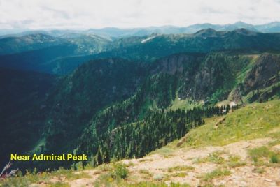 From the saddle the stateline trail heads moderately down the broad ridge almost to Mud Lake where it connects with trail #104 coming from Mud and North Cedar Log Lake; North Cedar Log is less than a mile. The next 3.5 miles will be a dry hike so stop in at Mud Lake if needed. The water is a little stale but usable.
Take the left fork at the junction above Mud Lake; it is around a 900 foot climb over 1.5 miles to the high point before the trail starts down to Vann Lake from Admiral Peak. The summit of Admiral Peak is less than 200 feet from the point on the ridge so a good opportunity to make the summit.
From this high point it is 2 miles of downhill to Vann Lake. Vann Lake contains 10+ inch Cutthroat Trout and the fishing is generally good. The campsite at the lake is flat and has lots of room. The stateline trail crosses the outlet and switchbacks up through an old fire above the lake to the saddle above Fish Lake. This 1 mile climb will feel worse than it is if you have been hiking all day as the long ascents and descent take their toll.
From the saddle above Vann Lake the trail descends moderately for 1/2 mile to the junction with the trail from Bruin Hill and Kelly Creek. There isn't an actual sign at the junction but rather there are individual signs less than 100 feet along each trail before the junction. Take the right fork down the hill towards Fish Lake. Once at the lake follow the road right around the lake to the second outhouse where trail #738 connects with trail #419 coming up from the Lake Creek trailhead. Trail #738 heads up to the left of the outhouse & back to the stateline and the end of this description.