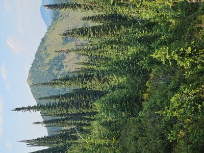
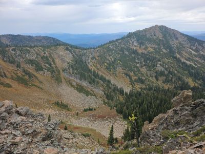
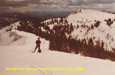
What to Expect: This 10.5 mile section of Stateline Trail #738 is also mostly a dry hike outside of snowbanks early in the summer and 1 reliable water source in a small basin around the halfway mark. This small basin is between Illinois and Graves Peak and just 200 feet below the trail. Hoodoo Creek alongside Rawhide Road is also a year round stream but is right at the end of the description to Hoodoo Pass. Jim Cyr, Hiking Mineral County, has a description of an old Forest Service Guard cabin and spring 200 feet below the trail that is somewhere past the Upper Oregon Lake overlook, but I have never been to it.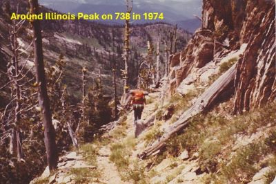 The trail doesn't have any real steep sections but the area around Illinois and Graves Peaks are the hardest part of the route. Illinois Peak is the highest peak between Thompson & Lolo Passes that straddles the Idaho/Montana border and well worth the 1/4 mile hike to the summit. On a clear day views are outstanding all around with the Mission Mountains visible to the North. There are just 3 lakes along this section of the divide; Upper Oregon, St Joe Lake (ID) and Trail Lakes. The Upper Oregon Lake is just off the stateline (300 ft) but the trail is a little primitive but doable. St Joe Lake has a good trail down to the lake but it is almost 1,000 foot drop and a grueling climb out. Trail Lake is accessible via trail #156 from the stateline; a nearly 2 mile hike. The small basin between Illinois and Graves Peaks could be a good option for a night.
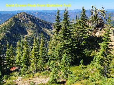
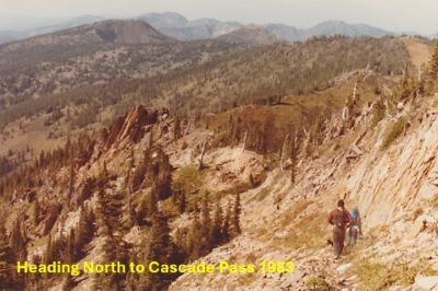
Getting There - Cascade Pass (Missoula Lake Saddle): From Superior, take Cedar Creek Road #320 and head toward Missoula Lake and Cascade Pass, a distance of 25 miles; stay on the main road as there are several other roads that connect. Stay left and cross the bridge near the 6 mile mark, the right fork is the Lost Creek road. At mile 12 you will cross a small bridge and then intersect a main logging road coming out of Rabbit Creek, stay straight. Another 1.5 miles will bring you to the intersection with road #388 (left) which will take you to the Gildersleeve Mine, Freezeout Pass and eventually Trout Creek Road #250. The intersection is signed, stay straight and go up the hill. After a series of steep switchbacks, the road tops out on Miller Saddle and begins a descent for the next couple miles with some good views of the stateline.
 After coming off Miller Saddle, (about 20 mi) there will be an intersection at the bottom of the drainage. Stay straight crossing Oregon Creek. The right fork at this intersection (road #7763) heads down the hill to the Big Flat; the left fork will take you up to the Oregon Lakes trailhead (1/2 mi). At mile 24 the road over to Missoula Lake Campground and it's trailheads takes off down and right, stay straight and in another mile you will top out on Cascade Pass. There has been quite a bit of logging up the Cedar Creek drainage and road and looks to continue into the future. Usually, there is a large lighted sign at the end of the pavement indicating hauling, so don't assume you are the only one on the road.
Trail #738 Description North to South: Starting on Cascade Pass head south on the obvious 4-wheeler trail.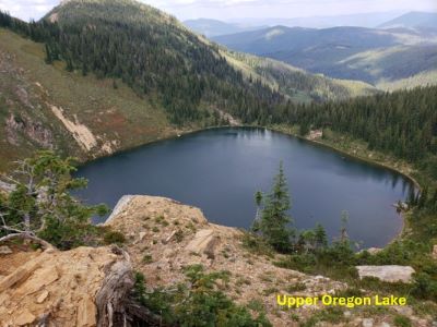 If you are hiking through and not starting here, there is a good stream that drains the nearby basin about 1/2 mile down the road on the Montana side. The initial 1/2 of a mile of the trail is beat up and rocky from the motorized traffic. The trail transitions into a nice single-track trail in less than a mile up the hill. In 1.25 miles you will arrive back on the stateline ridge. From here you can look down at the Upper Oregon Lake. You can also see (up and left) a primitive trail that will take you across the hillside and down to the lake. If you go up that ridgeline a 1/4 mile there are good views of all 3 Oregon Lakes. Per Jim Cyr, Hiking Mineral County, has a description of an old Forest Service Guard cabin and spring 200 feet below the trail that is somewhere past the Upper Oregon Lake overlook, but I have never been to it.
Continue on the trail which is very mellow (no big hills) and well defined for another 1.5 miles where the trail splits with the left staying on the open ridge and the right descending gradually along the hillside. Either fork is acceptable as they reconnect in a 1/4 mile on a grassy open slope. You can see where the left fork comes down the hill. For the next half mile, you cut across the upper reaches of Illinois Gulch with an unhindered view of the North Face of Illinois Peak. You can also see several mine tailings a few hundred feet down in the upper part of the basin from past mining activities.
The trail soon passes back into Idaho and starts climbing around the backside of Illinois Peak. The trail will split with the unsigned right fork going down the ridge toward Gold Crown Peak and eventually down to St. Joe Lake, about a mile down the hill from Illinois Peak. It is almost 1,000 feet down to St. Joe Lake, it is a grueling climb back out. Stay to the left on the main trail. In a couple hundred feet the trail splits again with the left fork heading up to the summit of Illinois Peak, a distance of 1/4 a mile.
 The right fork continues down towards the saddle between Illinois and Graves Peaks. As you pass the saddle and work your way around the north side of Graves Peak, look for a primitive trail heading down to the shallow basin below you. At one time there was a trail that would take you from this basin down to St. Joe Lake, but I don’t know if this is a viable route anymore. This is the only available water until you reach Rawhide Road and Hoodoo Creek in 4 miles.
The main trail continues around Graves Peak and descends the entire way back to the state line ridge. Soon you will hit an intersection where trail #156 connects from Trail Lake.
The last mile before connecting with Rawhide Road is a gentle uphill grade. At 8 miles, there will be a motorized use trail that will take you to the left and down to Rawhide Road. Rawhide Road used to be the main road over Hoodoo until the current Trout Creek Road was built in the 1950’s after the Diamond Match lumber mill was built and the logging camp was established at the Cedars. Follow this rough road down to the main Trout Creek Road #250 and then up the main road for a 1/4 mile to Hoodoo Pass for a final 10-mile trip; 11 miles if you go up to the Illinois Peak summit and down into the basin for water.
 If Hoodoo Pass, is your destination and spending a night then there are several good sites along Rawhide Road next to Hoodoo Creek. There are also a couple places to camp back down the main Trout Creek Road along Hoodoo Creek within a 1/2 mile of Rawhide Road.
Getting There - Hoodoo Pass (Trout Creek Road #250): At Superior, take Diamond Road east past the Town Pump Gas Station for 6 miles; passing the Bark mill and the Magone Ranches to the end of the pavement where the road changes to Trout Creek Road (#250). Continue up Trout Creek Road (~19 miles), passing the Trout Creek Campground and the Heart Lake trailhead until you top out on Hoodoo Pass on the Idaho/Montana border. The trailhead has no vault toilet so use the one at the Heart Lake trailhead if needed.
Trail #738 Description South to North: From Hoodoo Pass, go back down the road (MT side) a 1/4 mile and head left up Rawhide Road. This road is rough but drivable with a pickup for more than a mile if you desire to cut off a mile or so from your day. But this description is assuming a hike from Hoodoo Pass. There is a trail that heads straight up the hill about a mile up Rawhide Road but I am unsure the condition as of this writing. Follow Rawhide Road to a sweeping left hand switchback; leave the road on a single track trail that will connect with the stateline trail in a 1/4 mile.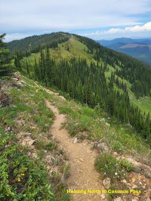 This early section of the stateline trail has a gentle downhill grade for a mile that you will have to make up later as you approach Graves and Illinois Peaks. At mile 3.75 you will intersect trail #156 coming out of Trail Lake, which may be or may not be signed any longer. I have not been down this trail to the lake so I can't comment on its condition. It is not until you break out of the trees (mile 4.75) as you approach Graves Peak do you have any views. This section from Hoodoo Pass is probably the least inspiring section on the entire stateline trail.
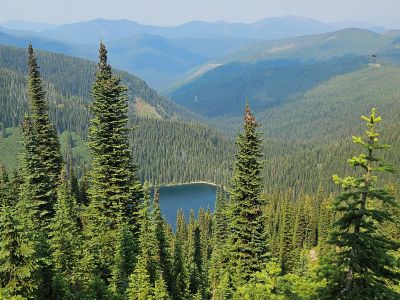
As you reach the West ridge of Graves Peak the country opens up and there are great views of Illinois Peak, St. Joe Lake, and the surrounding country. As you round onto the North side of Graves Peak, look for a primitive trail that heads down into the shallow basin and small pond, just 200 feet below. This is the only easy and reliable water source along the trail outside of snow during early summer. There used to be a trail that would wind around the basin and down to St. Joe Lake but I don't know if that is a viable route to the lake anymore.
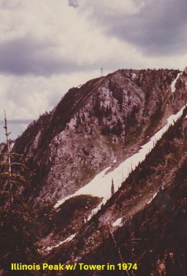
 Approaching Illinois Peak look for a primitive trail that heads up to the summit via the stateline if you are planning on making the summit. It is worth going to the summit as the views are outstanding in all directions. When the tower was still up, you could see it for miles in either direction, even over past the Siamese Lakes. Otherwise stay left lower around the summit area to the intersection with a trail that heads steeply downhill to the left towards Gold Crown Peak and eventually St. Joe Lake. It is about a mile down to St. Joe Lake and 1,000 foot elevation loss. It would be a very tough climb out with a full pack, it was bad enough with a day pack the couple times I have completed it.
Continue around the back side of Illinois Peak, listen for Pika's in the rocks along the trail. Eventually, the trail will swing over to the Montana side of the stateline where great views of the North Face of Illinois Peak are present along with the upper reaches of Illinois Gulch and the old mining claims there. After about 1/2 mile the trail will swing over to the Idaho side for the duration, except for above the Upper Oregon Lake where the trail is on the stateline for a short distance.
If you are planning on spending the night at the Missoula Lake Campground, may I suggest an alternative. From the overlook above Upper Oregon Lake, head up the ridge above the lake to the primitive trail that leads across the hillside, over to the low saddle and down to the Upper Oregon Lake; see the Upper Oregon Lake description for more details. The fishing is great for Brook Trout and there is a nice campsite near the outlet. The next day it is a short 1 mile hike over the low saddle and down to the main road just 1/2 mile from the pass or the campground.