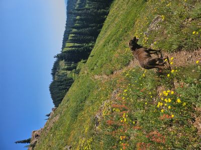
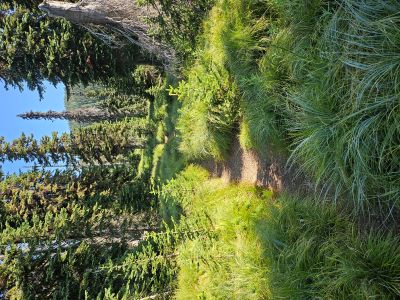
What to Expect: 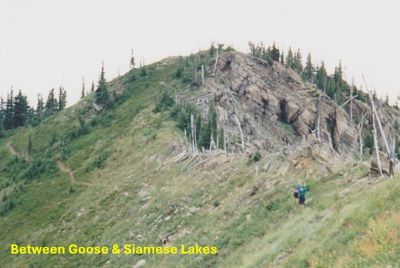 This 9.5 mile section of Stateline Trail #738 is a fairly dry hike outside of snowbanks and 2 tarns/lakes that are reasonably accessible from the stateline trail. The trail has some moderate sections that are mixed in with some very steep grades, this is a tough section of the stateline with not a lot of level grades. That being said, this section is absolutely spectacular and definitively the best continuous stretch along the Great Burn stateline. The trail can be sparse and primitive in sections, but there's no risk of losing it. Lakes along this route are the 2 Steep Lakes (ID), Straight Lake, Upper Siamese Lake, Lower Siamese Lake, W Fork Fish Creek Lake 2, and Fish Lake (ID) at the end.
The easiest water source is W Fork Fish Creek Lake 2, about 3/4 of the way to Fish Lake and of course Fish Lake at the end. The small tarn about half way on the Montana side, called Puddle Lake, as you pass by the Steep Lakes is accessible at 150 ft down the hill. It is very shallow, so not sure how clean the water may be late in the summer. There isn't a lot of shade either as you spend significant time directly on the ridge or passing through some old fires. Straight, Upper Siamese and W Fork Fish Creek Lake 2 are your best bets for camping. Straight Lake has a primitive trail down to the lake from the stateline; it is actually a good trail but sometimes sparse. The Upper Siamese has a rugged trail to the lake and W Fork Fish Creek Lake 2 (no fish) is an easy level traverse to the lake, but has lots of bugs. Both Straight and Siamese have good fishing.
Getting There - Goose Lake: I have provided a descriptions to the trailhead on past sections as a road intersects the stateline, but in this instance I will just reference the individual descriptions for Goose Lake. They contain trailhead and trail descriptions from several directions; so see the Goose Lake page for more detail.
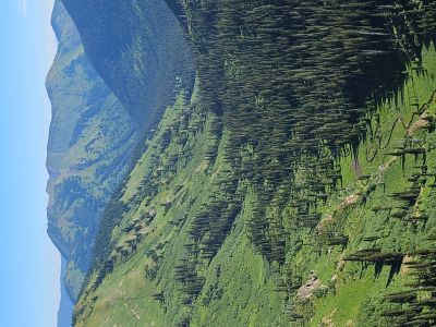
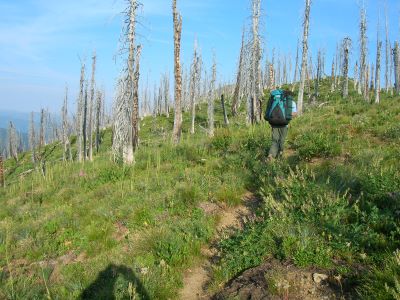
Trail #738 Description North to South: Starting at the outlet of Goose Lake and the intersection of trail #414, stay left on the state line trail. The trail switchbacks and climbs moderately for over a mile back to the main state line ridge. From there the trail climbs steeply up the ridge for several hundred feet. There is a more primitive trail that looks like it angles up the slope and bypasses the steep section, but I haven't been on it before.  In the first 2 miles you will regain almost all the elevation that was lost dropping into Goose Lake. This is the toughest stretch between Goose and Fish Lake going in this direction.
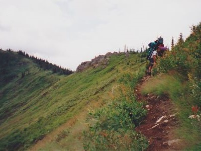
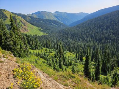
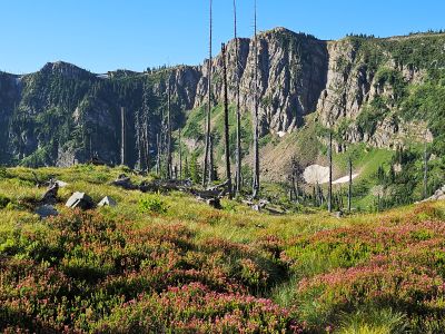
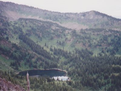
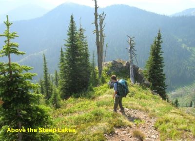
At the 2-mile mark you will arrive at a nice flat knoll that has great views of the Straight Creek drainage below, Crater Mountain, back toward Hoodoo Pass and beyond to Illinois Peak and your upcoming route. A good place to take a break after a hard 2 miles. There is large tarn below that is too far for getting water. For the next 2.0 miles the trail stays around 7,000 feet while crisscrossing from Idaho to Montana. Great views are almost constant as you pass by the aptly named Steep Lakes in Idaho and the upper reaches of Straight Creek and Straight Lake in Montana. The trail is still a bit tough as it is rocky and primitive in places.
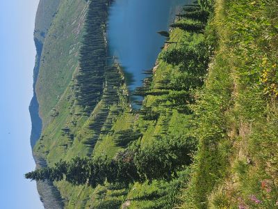
About the 4 mile mark, just before you make a steep climb, there is a small tarn down the hill to the left in Montana that is only 150 feet off the stateline trail. I have never needed to access it, but I will definitely make a visit a priority the next time I am across that section so I can comment on it.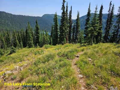 You climb up to 7,300 feet and after the last good look at the Upper Steep Lake, the trail descends gradually down the ridge through an old fire past Straight Lake. There is a primitive trail down to Straight Lake that angles down across the hillsides, see the Straight Lake page for a visual depiction & description.
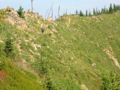
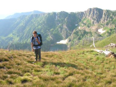
From the saddle above Straight Lake, the stateline trail continues straight on the ridge and climbs back to over 7,000 feet before starting the descent to the saddle above the Upper Siamese Lake. Make sure you take the time to pause at several overlooks along the way as they have some great views. There are no trees across this section so it can be hot. Near the point where the Upper Siamese Lake comes into view, there is a primitive trail that takes off to the left and heads down the dividing ridge between Straight Creek and the West Fork of Fish Creek.
This trail will take you to Chilcoot Pass and Straight Peak. I have hiked it a couple times to Chilcoot Pass, but I haven’t been on it in a couple decades and 2 fires have been through the area since then, but when I was at Chilcoot Pass in 2025 the trail was still visible. It is a tough trail. A couple hundred feet down the main ridge trail will bring you to the intersection of the trail accessing the Upper Siamese Lake; 6.25 miles into the section.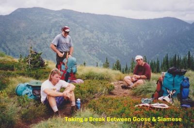 The trail down to the Upper Siamese is steep and rocky but no worse than many other trails down from the stateline.
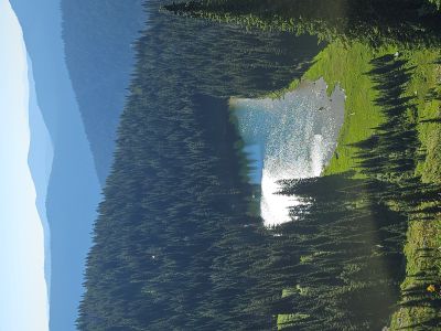
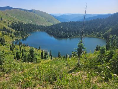
From the Upper Siamese junction, the trail briefly climbs again then undulates for the next mile passing above 2 tarns, the second is the one that you can easily get to for filtering water or letting your hikiing partner take a swim. As you pass above the 2nd tarn named W Fork Fish Creek Lake 2 by the MT Fish & Game, the trail will do a couple steep switchbacks down an open slope, then swing east into the trees towards the tarn/lake and level off a bit.
Look for a primitive trail to the left just before you continue steeply down the ridge and below the level of the tarn. It is a 0.1 of a mile mostly level walk across this lightly brushed flat where you connect with the trail that comes up from below. There is another trail that starts down the hill 100 feet that also takes you to the tarn which is better used if coming from the South. The main trail then continues its descent down the state line ridge to a nice flat and the trail gently traverses left around the hillside for about 1/2 mile across the a very steep slope above Foley Basin.
 Be aware that early in the summer, before July 4th, there can be a snowbank across this very steep slope. I met a couple women (Michelle & Dawn) in late June of 2025 at Goose Lake that had to turn around because of the snow. Once past this slope the trail dives steeply for a bit and then intersects at mile 9 with trail #101 coming out of Foley Basin and the West Fork of Fish Creek. It is about a 1/2 mile to the right down to Fish Lake for a total of 9.5 miles.
Getting There - Fish Lake: I have provided a descriptions to the trailhead on past sections as a road intersects the stateline, but in this instance I will just reference the individual descriptions for Fish Lake. They contain trailhead and trail descriptions from several directions; so see the Fish Lake page for more detail.
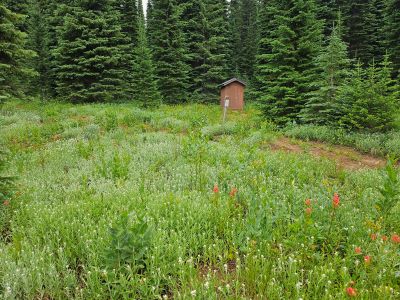
Trail #738 Description South to North: Starting at the outhouse at Fish Lake where the stateline trail meets trail #419 (its a road) coming out of Lake Creek, head moderately up the hill where the trail meets trail #101 from Foley Basin and the West Fork of Fish Creek. Head North (left) from this signed junction. The trail quickly leaves the flat and climbs steeply for 1/4 mile. The trail then traverse gently around a very steep hillside with extended views of the Foley Basin area and upper West Fork of Fish Creek. Be aware that early in the summer, before July 4th, there can be a snowbank across this very steep slope. I met a couple women (Michelle & Dawn) in late June of 2025 at Goose Lake that had to turn around because of the snow.
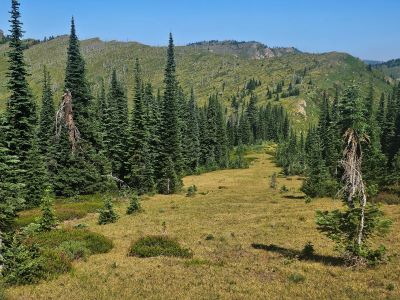
Once the trail passes around the hillside there will be nice flat for a rare stroll. As you start to climb again, there will be a junction where the stateline trail climbs steeply to the left and a lesser trail splits off to the right. This right hand fork will take you to a small tarn named W Fork Fish Creek Lake 2 by the MT Fish & Game, it is less than 1/4 mile to the lake. There is no fish in the lake and it is a bit buggy, but is a nice place for your dog to take a swim. If you go to the lake/tarn you can cut off a little distance coming back by cutting across the flat where you pick up the stateline trail just above the previously mentioned steep section.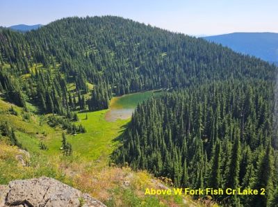 The stateline trail then breaks out of the trees and makes a steep climb up the ridge until high above the lake you just visited at almost 7,000 feet. The trail then descends briefly before passing above a second tarn and climbing back over 7,000 feet. The trail then descends again down to a saddle where the un-named primitive trail heads down to the Upper Siamese Lake, a little over 3.5 miles into the hike.
From there the stateline trail climbs steadily up past the primitive trail to Chilcoot Pass to the top of the stateline and continues moderately up for more than a mile. There is no shade along this stretch and can be very hot. Make sure you take the time to pause at several overlooks along the way as they have some great views. The trail then drops a bit to a saddle above Straight Lake. There is a primitive trail down to Straight Lake that angles down across the hillsides, see the Straight Lake page for a visual depiction & description. The stateline trail continues to head up the ridge through the burn to the highest point along this section at 7,300 feet and your first look at the Steep Lakes. This section from the Upper Siamese is the most difficult going in this direction.
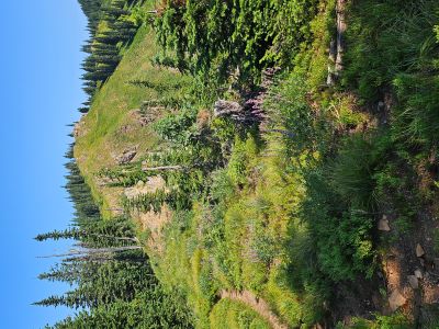
The trail then descends down 500 feet over 1/2 mile to a spot where you can access a small tarn (Puddle Lake) that is only 150 below the trail to the right. I have not been down to the tarn but will do so the next time I am by the area so I can comment on it. From there, the trail stays between 6,800 and 7,000 feet as it crisscrosses the stateline for the next couple miles. The views are outstanding with the Steep Lakes in Idaho and Straight Creek, StraightLake & Crater Mountain in Montana. At the 7.5 mile mark you will get to a nice open knoll with great views all around. From this knoll, the trail drops steeply down to a saddle where the trail leaves the stateline and switchbacks down to Goose Lake and the end of this description at 9.5 miles.