Getting There: Take the Fish Creek Exit on I-90 and proceed up Fish Creek Road #343, then the right fork on road #7750 (Iowa State Research Center) that ends at the Clearwater Crossing in 6.75 miles. The clearwater crossing has a small campground (3 sites), 2 vault toilets and a Forest Service Guard Station. Take trail #103 (North Fork Trail) that takes off to the right of the Guard Station on an old road. Stay on this trail for about a half mile, the trail splits, with the North Fork Trail #103 heading up to hill to the right and Straight Creek Trail #99 staying straight along the creek. There is a sign at this junction.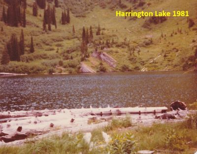 The trail up Straight Creek is just a tough go. It’s brushy and rocky. It doesn’t have too many steep sections, but it is at a grade almost all the way. Straight Creek Trail #99 continues along the creek bottom to the first of several creek crossings for the day. Cross the North Fork of Fish Creek and Straight Creek, they come together at this crossing. If you change out of shoes for the crossing, don’t bother putting your hiking shoes back on as there is another crossing of Straight Creek in less than a hundred yards. There are crossings at 2.5- and 3.35-mile markers.
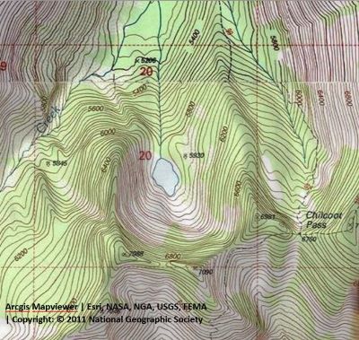
After a little more than 5 miles you will come to what I have named the Staircase Falls, a good place to take a break as this is one of the few open areas to view back towards the Clearwater Crossing and up towards the state line. There is a well-developed horse camp at the 6-mile mark. Another mile up the trail and another creek crossing or two you will get to a split in the trail.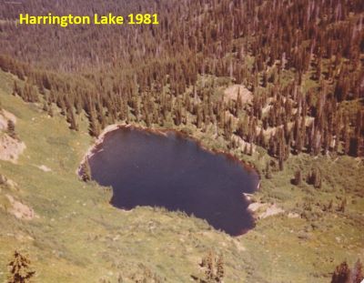 The left fork will continue as trail #99 and will take you up over Chilcoot Pass and down into the Lower Siamese Lakes. At this point you need to stay straight and look for another crossing of Straight Creek. This may require some searching as the crossing is not obvious. After crossing the creek, follow the trail until you cross the creek one more time. At this point you are directly below Harrington Lake, head straight up of the hill following the best path you can find through the trees.
I have seen a couple other descriptions for getting to Harrington Lake via Straight Creek. One indicated to bushwack up the drainage coming out of Harrington Lake from the point that the trail starts up to the hill to Chilcoot Pass. The other is to proceed up towards Chilcoot Pass a 1/4 mile or so and then angle across the hillside and around to Harrington Lake. Neither one of these sounds all too enticing based on how much undergrowth and deadfall I have experienced the past few years while attempting to follow cross-country routes that were written back in the late 60’s and 70’s.
At the Lake: Harrington Lake isn’t all that big and the shoreline is accessible all the way around the lake. I do not know of any campsites, but at the time we didn’t go around the entire lake shore, so there should be something in the trees past the outlet.
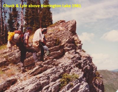
The first time, currently only time, I made it to Harrington Lake was back in 1981 with Chuck Bauer, Steve Bauer and Lyle Case. We followed Straight Creek all the way to the headwall of the state line then climbed over the ridge above the Upper Siamese Lake, then down that ridge almost to Chilcoot Pass. We dropped straight down the hill to the lake. There was a trail that we could follow most of the way to the lake; the brush wasn’t too thick at the time.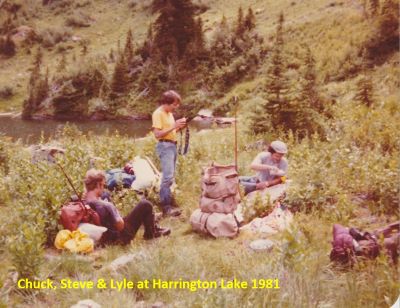 We stayed at the lake for a couple hours; then went down the hill to pick up the trail in Straight Creek that we came in on and then camped at the Horse Camp at the 6-mile point. Lyle did some fishing and caught a couple nice fish; I think one was at least 15 inches. We only stayed a couple hours at the lake, just enough time to take a swim and fish a little. Chuck hooked a very nice fish but couldn’t land it.
Another option would be to come from the Lower Siamese via the West Fork but that is a longer hike (12+ miles one-way) and an overnight stay at the Lower Siamese Lake would probably be desired. It is 11 miles to the Lower Siamese and then a very tough 1.25 mile (700 ft) climb before dropping into Harrington Lake.
Straight Creek is one of the roughest trails along the state line. In addition to the multiple crossings, the trail is rocky and brushy. The grade is not particularly steep but is unrelenting the entire length. Don’t expect to breeze along like you can going up the North or West Fork trails. The time it takes me to make 5 miles up Straight Creek is the same to make 7 miles up the North Fork and I did them both during the same summer. Climbing up over Chilcoot Pass is a separate grind in itself. I have been up & down Chilcoot Pass a couple times and it is harder than any topo map will indicate.