Getting There: Take the Fish Creek Exit on I-90 and proceed up Fish Creek Road #343, then the right fork on road #7750 (Iowa State Research Center) that ends at the Clearwater Crossing in 6.75 miles. The Clearwater Crossing has a small campground (3 sites), 2 vault toilets and a Forest Service Guard Station. Take trail #103 (North Fork Trail) that takes off to the right of the Guard Station on an old road. Stay on this trail for about a half mile, the trail splits, with the North Fork Trail #103 heading up to hill to the right and Straight Creek Trail #99 staying straight along the creek. There is a sign at this junction.
The left trail (#99) up Straight Creek is just a tough go. It’s brushy and rocky. It doesn’t have too many steep sections, but it is at a grade almost all the way. Straight Creek Trail #99 continues along the creek bottom to the first of several creek crossings for the day. Cross the North Fork of Fish Creek and Straight Creek, they come together at this crossing. If you change out of shoes for the crossing, don’t bother putting your hiking shoes back on as there is another crossing of Straight Creek in less than a hundred yards. There are crossings at 2.5- and 3.35-mile markers. After a little more than 5 miles you will come to what I have named Staircase Falls, a good place to take a break as this is one of the few open areas to view back towards the Clearwater Crossing and up towards the state line. There is a well-developed horse camp at the 6-mile mark. Another mile or 2 up the trail, a couple switchbacks and another creek crossing or two you will get to the start of the grade to Chilcoot Pass.
It is 2.25 miles and an elevation gain of 1,700 feet over that distance, so it is a grind to the pass, with the last mile being incredibly hard. Trail #99 turns into trail #114 on the pass and heads right down along the hillside to the Lower Siamese Lake in 1.25 miles for a total of 11.0 tough miles. This route up to the lake is probably the hardest overall hike that I describe on this site.
Also, on Chilcoot Pass trail #510 takes off to the east and uphill towards Straight Peak, then Cedar Peak and eventually back to the West Fork of Fish Creek. This would be a fun option as a loop back to the Clearwater Crossing via the West Fork of Fish Creek. My dad told me once that there are more than 30 switchbacks between Cedar Peak and the West Fork trail #101; I have been up 20 of them in 2025. Also in 2025, the FS is still working to clear hundreds of deadfall from the fire on/near Cedar Peak, so best to check with the 9-mile ranger district.
About a 1/4 mile down the trail from Chilcoot Pass you can pick up the un-named ridge trail to the right that will take you to the Upper Siamese and the state line trail #738. This trail takes off at the low saddle where you can look directly down into Harrington Lake. This is a primitive trail whose condition is unknown as I have not hiked it in many years and several fires have burned the ridge bare.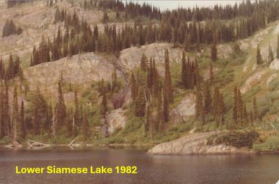 There is also a game trail that takes off a couple hundred feet before you get to the Lower Siamese that angles up along the hillside to the Upper Siamese Lakes. I have been down this trail from the upper lake once many years ago, so its current condition is also unknown. This is a primitive trail so don’t expect much from it. Joelle G. from the GBCA hiked down it in 2025. She said it was doable but hard to find in places, so have your navigation hat on.
Getting There: Take the Fish Creek Exit on I-90 and proceed up Fish Creek Road #343, then the right fork on road #7750 (Iowa State Research Center) that ends at the Clearwater Crossing in 6.75 miles. The clearwater crossing has a small campground (3 sites), 2 vault toilets and a Forest Service Guard Station. Cross the West Fork of Fish Creek on the stock bridge to pick up trail #101. Follow trail #101 for 9.25 miles to Foley Basin where trail #114 to the Lower Siamese intersects.
 Along the way you cross the West Fork at mile 3 where you intersect trail #110 coming out of Cedar Log Creek and a camp site and swimming hole is just 100 yards from the crossing. The bridge is old, it has been there in excess of 50 years as I remember it back then. Nowadays a single hiker can make the bridge flex by just walking across so it might be gone in a few years.
At five miles the trail (#121) out of Indian Creek crosses the West Fork and connects with trail #101. The trail continues up the valley to Foley Basin at a moderate grade with a steeper grade around the couple switchbacks after passing by the creek coming out of the Siamese Lakes. At Foley Basin the left fork (#101) climbs up to the state line and Fish Lake with the right fork, trail #114 heading to the Lower Siamese Lake. There used to be a couple of good camp sites here at the junction, but may be more primitive today. There was signage the last time I was at the intersection in 2025. The Lower Siamese Lake lies about 2 miles up trail #114. It is a hard 2 miles to the lake from Foley Basin, so trail #114 is not to be taken lightly.
Getting There: At Superior, take Diamond Road east past the Town Pump Gas Station for 6 miles; passing the Bark mill and the Magone Ranches to the end of the pavement where the road changes to Trout Creek Road (#250). Continue up Trout Creek Road (~19 miles) until you top out on Hoodoo Pass on the Idaho/Montana border. Continue on Road #250 into Idaho for about 11 miles. About a tenth (0.1) of a mile before crossing the Middle Fork of the Clearwater River, road #250 crosses Long Creek and stays left of the Clearwater River. If you cross the river and get to the Cedars Campground, you have gone too far. Stay on road #250 for another half (.5) mile then stay left on road #295 up Lake Creek for about 4.5 miles.
 There will be a picnic area / trailhead with a vault toilet at the intersection. The left fork (road #5450) goes for a mile to a gate and the trailhead to Goose Lake and Steep Lakes; the right fork continues up Lake Creek for 1.5 miles to the trailhead for Fish Lake. The left fork (road #5450) goes for a mile to a gate and the trailhead to Goose Lake and Steep Lakes; the right fork continues up Lake Creek for 1.5 miles to the trailhead for Fish Lake. Road #295 becomes trail #419 at that point; okay it is a road. Stay on this well-defined route for 6 miles to Fish Lake, the largest lake in the Great Burn area. Trail #419 moderately climbs up the valley crossing two creeks (Siam & Japanese) and several other small creeks with just the middle couple miles a bit steeper, so it is easy to make good time. Once you cross the 350+ foot boardwalk you are about 1/2 mile from the lake.
Look for signage and trail #738 heading left up the hill when you arrive at Fish Lake; this at the 2nd outhouse you encounter. Head up to the left on trail #738 to the state line, where you will intersect with trail #101 that leads down into the West Fork of Fish and eventually to the Clearwater Crossing.
Head down trail #101 into Foley Basin for about 1.25 miles and take trail #114 that leads to the Lower Siamese Lake. This trail takes off to the left prior to crossing the creek. There was signage the last time I was at the intersection in 2025. The Lower Siamese Lake lies about 2 miles up trail #114. It is a hard 2 miles to the lake from Foley Basin, so trail #114 is not to be taken lightly.
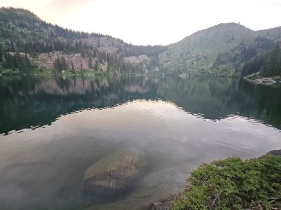
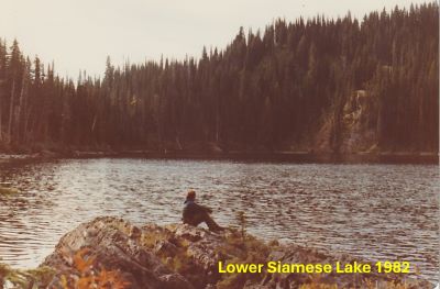
At the Lake: The Lower Siamese is a good-sized lake with several well-established and large campsites past the outlet. The shoreline can be steep and brushy in places but there are areas that provide good access to cast for Cutthroat Trout. I didn't fish in 2025 so I can't vouch for the fishing.