Getting There: At Superior, take Diamond Road east past the Town Pump Gas Station for 6 miles; passing the Bark mill and the Magone Ranches to the end of the pavement where the road changes to Trout Creek Road (#250). Continue up Trout Creek Road (~19 miles) until you top out on Hoodoo Pass on the Idaho/Montana border.
Take stateline trail #738 for 4.5 miles to the split where the left fork heads down to the saddle between Pearl and Dalton Lake. Stay right on #738 as it passes above Dalton Lake and heads up to 7,250 feet and a view of the Middle and Upper Trio’s. The trail then starts heading down to Goose Lake (5,800 ft), this is the first available water since Hoodoo Pass except for some possible snowbanks along the way. The total distance to Goose Lake is a solid 7 miles.
Head down the North Fork Trail (#103) of Fish Creek for about 1/4 mile where a good un-signed trail, #338 splits off to the left; the North Fork Trail #103 continues down the hill. Trail #338 meanders through the trees and in about a mile you arrive at the Lower Trio Lake. Even though the distance is a bit over 8 miles, it is a hard route as there are significant elevation changes across the stateline trail and water is not readily available. If it is a hot day, the hike can be pretty hard.

Getting There: At Superior, take Diamond Road east past the Town Pump Gas Station for 6 miles; passing the Bark mill and the Magone Ranches to the end of the pavement where the road changes to Trout Creek Road (#250). Continue up Trout Creek Road (~14 miles) to the Heart Lake Trailhead. There is a vault toilet and parking for over 20 vehicles.
Trail #171 takes off on the far side of the parking area. The trail wanders through the bottoms, gradually climbing up the valley for 2+ miles. Then the trail turns up the hill and climbs much steeper for the next 3/4 mile to Heart Lake. Cross the outlet onto trail #175 and continue around Heart Lake to the far end. The trail continues to climb and switchback up the hill for 1 mile to Pearl Lake. Continue around Pearl Lake to the low saddle overlooking Dalton Lake. Turn right and follow the trail up the ridge to the stateline trail #738.
There is a little bit of a break above Dalton Lake but then the trail continues to climb to the high point of 7,250 ft. From there you lose almost 1,500 ft to Goose Lake. Head down the North Fork Trail (#103) of Fish Creek for about 1/4 mile where a good un-signed trail, #338 splits off to the left; the North Fork Trail #103 continues down the hill. Trail #338 meanders through the trees and in about a mile you arrive at the Lower Trio Lake.
 This route is a bit longer than the Hoodoo Pass route with water available at least to Pearl Lake but you are climbing steadily (2,600 ft) for 6 miles. Kind of a pick your poison when hiking from the Trout Creek side. The hike from Heart Lake trailhead to the high point is a bit of a grind if completing it in a day with a full pack.
Getting There: Take the Fish Creek Exit on I-90 and proceed up Fish Creek Road #343, then the right fork on road #7750 (Iowa State Research Center) that ends at the Clearwater Crossing in 6.75 miles. The Clearwater Crossing has a small campground (3 sites), 2 vault toilets and a Forest Service Guard Station.
 Take trail #103 that takes off to the right of the Guard Station on an old road. After about a mile the trail will split with trail #103 going to the right an up the hill; Straight Creek trail #99 stays straight. Stay on this trail for about 11.5 miles passing the Greenwood cabins, crossing French Creek and going through Fletcher Gulch over that span. There is plenty of water along almost the entire length of the trail.
About a 1/4 mile from Goose Lake, there is an un-signed trail (#338) that takes off to the right. Follow this trail for about a mile to the Lower Trio Lake. The North Fork trail is not too bad; it is well maintained and is a gradual climb up the valley until the last couple miles from Fletcher Gulch. Of the trails starting at or near the Clearwater Crossing, it is usually in the best condition as horse riders frequent the trail up to Fletcher Gulch and keep the trail clean.
Getting There: If you don’t mind taking a bit longer drive. At Superior, take Diamond Road east past the Town Pump Gas Station for 6 miles; passing the Bark mill and the Magone Ranches to the end of the pavement where the road changes to Trout Creek Road (#250). Continue up Trout Creek Road (~19 miles) until you top out on Hoodoo Pass on the Idaho/Montana border. Continue on Road #250 into Idaho for about 11 miles. About a tenth (0.1) of a mile before crossing the Middle Fork of the Clearwater River, road #250 crosses Long Creek and stays left of the Clearwater River. If you cross the river and get to the Cedars Campground, you have gone too far. Stay on road #250 for another half (.5) mile then stay left on road #295 up Lake Creek for about 4.5 miles. There will be a picnic area / trailhead with a vault toilet at the intersection. Take the left fork road #5450 for about 1 mile and park at the turnaround at the gate. The first mile of the trail (#414) is the continuation of the road, the road eventually narrows down to a trail. The trail rises gently with extended grades in the 1/2 mile around the Steep Creek crossing and last mile after passing through the meadows. The trail through the meadows can be a bit difficult to follow, but the trail runs fairly straight across each meadow.
I found in 2024 that there was a lot more brush than in the past; a lot of waist and occasional head high brush. If it has recently rained or is raining, it will be a wet hike (it was). The distance to Goose Lake is about 5.75 miles. There is plenty of water (~ 6 small crossings) on this trail so there is no need to carry water for the entire route as you do on some sections of the State Line Trail.
Once at Goose Lake follow the trail past the lake over the stateline and head down the North Fork Trail (#103) of Fish Creek for about 1/4 mile where a good trail, #338 splits off to the left; the North Fork Trail #103 continues down the hill. This intersection is NOT signed. Trail #338 meanders through the trees for over a mile until you arrive at the Lower Trio Lake for 7.25 miles total.

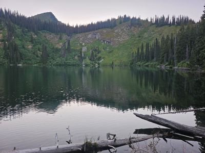
At the Lake: The Lower Trio is one of the better fishing lakes along the stateline, as it doesn’t get a lot of traffic due to its remoteness. It contains a natural population of Rainbow Trout. There are a couple sites to pitch a tent and the site is fairly sheltered. The shoreline can be difficult to navigate in places due to brush and heavy deadfalls. Alternatively, you can camp at Goose Lake and then make day trips to do some fishing. If you are heading back to Hoodoo Pass, I would suggest returning via the Upper Trio Lake then back to the state line trail by that route, see the Upper Trio Lake description. Look for the trail to the Upper Lake just a 100 feet past the only creek crossing on Trail #338, see the picture with Skye.
I like this route passing by the Upper Trio Lake better as it is more interesting and less of a grind than going back to Goose Lake and then making that tough climb back to the high point above Dalton Lake. You still climb the same amount of elevation but there is more flavor to it. Plus, there is water available for much of this route compared to no water from Goose Lake on.
As an alternative route, you can follow the Upper Trio Lake description from Hoodoo or Heart Lake Trailheads that comes down the primitive trail from near the high point and pass by the Upper Trio Lake; then follow the trail down to trail #338 and eventually to the Lower Trio Lake.
In 2025, I hiked from the Middle Trio Lake to the Lower Lake, a short distance of 1/2 mile. This was a cross-country venture where I climbed out of the Middle Trio to the dividing ridge between Fletcher Gulch and the Trio Lake Basin, hiked down the ridge and then dropped into the Lower Trio. That was one of the hardest 1/2 miles that I have done in a long time; didn't help that it was at the end of the day with a full pack. The climb back to the ridge was so steep with bear grass and bush. I did find a game trail down the ridge, but the drop into the Lower Trio was chocked full with deadfall and brush. Not a route I want to repeat or recommend to others.