Getting There: At Superior, take Diamond Road east past the Town Pump Gas Station for 6 miles; passing the Bark mill and the Magone Ranches to the end of the pavement where the road changes to Trout Creek Road (#250). Continue up Trout Creek Road (~19 miles) until you top out on Hoodoo Pass on the Idaho/Montana border.
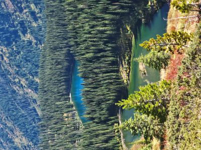
 Take the stateline trail #738 for 4.5 miles to the split where the left fork heads down to the saddle between Pearl and Dalton Lake. Stay right on #738 as it passes above Dalton Lake and heads up to 7,250 feet and a view of the Middle and Upper Trio’s. Proceed down the trail for about 1/3 mile to another overlook of the Upper Trio Lake.
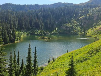
To your left is a marginal trail that angles down to the basin and stream that empties into the Middle Trio. The trail is well defined at the top but tends to fade out in the basin. Follow the least path of resistance along the stream and take a shallow angle towards the outlet of the Upper Trio Lake. Don’t drop into the lake too soon as it is very steep in places. It’s best to stay on the ridge longer than you think is necessary.
From the Upper Trio Lake head North from the campsite over the low saddle/ridge between the Upper & Middle lakes. This is a much easier route than trying to reach the lake directly down the basin. There is a primitive trail of sorts between the lakes; met it just as I was reaching the lake in 2025 when I came straight down the basin. Even though the distance is a bit over 7 miles, it is a hard route as there are significant elevation changes across the stateline trail and water is not readily available. If it is a hot day, the hike can be pretty hard.
Getting There: At Superior, take Diamond Road east past the Town Pump Gas Station for 6 miles; passing the Bark mill and the Magone Ranches to the end of the pavement where the road changes to Trout Creek Road (#250). Continue up Trout Creek Road (~14 miles) to the Heart Lake Trailhead. There is a vault toilet and parking for over 20 vehicles. Trail #171 takes off on the far side of the parking area. The trail wanders through the bottoms, gradually climbing up the valley for 2+ miles. Then the trail turns up the hill and climbs much steeper for the next 3/4 mile to Heart Lake. Cross the outlet onto trail #175 and continue around Heart Lake to the far end. The trail continues to climb and switchback up the hill for 1 mile to Pearl Lake.
 Continue around Pearl Lake to the low saddle overlooking Dalton Lake. Turn right and follow the trail up the ridge to stateline trail #738. There is a little bit of a break above Dalton Lake but then the trail continues to climb to the high point of 7,250 ft. From this high point, proceed down the trail for about 1/3 mile to another overlook of the Upper Trio Lake.
 To your left is a marginal trail that angles down to the basin and stream that empties into the Middle Trio. The trail is well defined at the top but tends to fade out in the basin. Follow the least path of resistance along the stream and take a shallow angle towards the outlet of the Upper Trio Lake. Don’t drop into the lake too soon as it is very steep in places. It’s best to stay on the ridge longer than you think is necessary. This route is a bit longer than the Hoodoo Pass route with water available at least to Pearl Lake but you are climbing steadily (2,600 ft) for 6 miles. Kind of a pick your poison when hiking from the Trout Creek side. The hike from Heart Lake to the high point is a bit of a grind if completing it in a day with a full pack.
From the Upper Trio Lake head North from the campsite over the low saddle/ridge between the Upper & Middle lakes. This is a much easier route than trying to reach the lake directly down the basin. There is a primitive trail of sorts between the lakes; met it just as I was reaching the lake in 2025 when I came straight down the basin.

At the Lake: There are no fish in the lake. I didn't find any official campsites, but you could camp in the grassy areas near the outlet. The only other time I have been to this lake is in early June 1980. Chuck & Jerry Bauer and I rode our motorcycles over to the high point and dropped straight down the hill into the basin and followed the stream bed to the lake. Actually, Chuck slipped standing on edge of a big snowbank at the high point and slid 100 yards down the hill; that is why we went that route. We then climbed up to the dividing ridge above Dalton Lake and hiked it back to our motorcycles.
I wish I had taken more pictures that day as the ridgeline really provides a unique view of Dalton Lake and down Fletcher Gulch to the North Fork of Fish Creek. The climb up the ridge line was super steep in places. There is a temptation to swing back off the ridge down to Dalton Lake. This is a bad idea as the brush is 10 feet tall and it is steep; it is definitely goat country. A friend from Superior had tried that route one time and from what he said, it was not a good route to go from Dalton to the Lower Trio.
The Middle Trio can also be accessed via the North Fork of Fish Creek or Goose Creek, but I chose not to create full descriptions at this time. From the Lower Trio Lake, I would hike to the Upper Lake and then over the low saddle. In 2025, I climbed to the dividing ridge with Fletcher Gulch, down the ridge and dropped into the Lower Lake. It is a tough climb out of the lake and route to the lower lake is full of brush and deadfall. A very hard go, just better to go the Upper Lake then cut across the low saddle.