

Getting There: At Superior, take Diamond Road east past the Town Pump Gas Station for 6 miles; passing the Bark mill and the Magone Ranches to the end of the pavement where the road changes to Trout Creek Road (#250). Continue up Trout Creek Road (~19 miles) until you top out on Hoodoo Pass on the Idaho/Montana border. Take the state line trail #738 for 4.5 miles to the split where the left fork heads down to the saddle between Pearl and Dalton Lake. Stay on #738 as it passes above Dalton Lake and heads up to 7,250 feet and a view of the Middle and Upper Trio’s. The trail then starts heading down to Goose Lake (5,800 ft), this is the first available water since Hoodoo Pass except for some possible snowbanks along the way.
 The total distance to Goose Lake is a solid 7 miles. Goose Lake is the only easily accessible water source between Hoodoo Pass and the lake. There are small lakes/tarns on the Montana side, but they are a steep climb down. The water coming out of Goose Lake is not the best, it is a bit warm and has some taste to it. If you would like fresher water, then go over to the inlet stream on the other side of the lake and filter the water there or go down the creek a few hundred feet.
Cross the outlet and take the left fork that continues up trail #738. The right fork, trail #414, will take you down Goose Creek to the trailhead there. After a couple of switchbacks the trail will line out towards the state line ridge, this is a bit more than a mile. The trail then heads steeply up the ridge, an ugly climb with a full pack. However, if you look to the left a bit there is a primitive trail that sidehills around this steep part and connects back up with the main trail.
At the 2 mile mark the trail climbs gently to a rocky point, the is a good spot to take a break and really look around. This is a spectacular viewpoint where most of the northern half of the Great Burn is visible.  You can look back to Hoodoo Pass and beyond to Illinois Peak, Crater Mountain dominates to the left and you are looking directly down Straight Creek toward the Clearwater Crossing in the West Fork of Fish Creek.
The trail continues along the state line alternating from Montana and Idaho for another 3 miles, passing by the appropriately named Upper and Lower Steep Lakes on the Idaho side of the ridge. After you leave the high point above the Upper Steep Lake hike down the long burned ridge you will come to a saddle and the stateline trail heads back up the hill. Backtrack from the saddle about 100 yards through a small band of trees where the primitive / game trail takes off from the stateline and angles down across the rocky hillside.
The first 100 or so yards are really faint and hard to follow but take your time. The trail soon becomes much more defined and easier to follow. The trail will angle down to a small basin, where there is water if you need it. The trail picks up again across the basin and continues along the hillside at a much gentler grade. ***Be careful as the trail has places covered in grass but no tread underneath, easy to take a nasty spill if you are "gawking and walking". After about 2/3 of a mile the trail will drop down to a flat bench with a snowbank, if early enough in the summer. Turn right and look for a game trail that angles down from the bench. This is a little faint at first but soons becomes very well defined. It is a bit steep but nothing bad; stay on the trail as it angles down to the inlet of the lake. See the picture with the route depiction in the pictures below.

Getting There: : If you don’t mind taking a bit longer drive. At Superior, take Diamond Road east past the Town Pump Gas Station for 6 miles; passing the Bark mill and the Magone Ranches to the end of the pavement where the road changes to Trout Creek Road (#250). Continue up Trout Creek Road (~19 miles) until you top out on Hoodoo Pass on the Idaho/Montana border. Continue on Road #250 into Idaho for about 11 miles. About a tenth (0.1) of a mile before crossing the Middle Fork of the Clearwater River, road #250 crosses Long Creek and stays left of the Clearwater River. If you cross the river and get to the Cedars Campground, you have gone too far. Stay on road #250 for another half (.5) mile then stay left on road #295 up Lake Creek for about 4.5 miles.
There will be a picnic area / trailhead with a vault toilet at the intersection. The left fork (road #5450) goes for a mile to a gate and the trailhead to Goose Lake and Steep Lakes; the right fork continues up Lake Creek for 1.5 miles to the trailhead for Fish Lake. Road #295 becomes trail #419 at that point. The trail is now back open for motorized traffic as of the spring of 2025. Stay on this trail/road for 6 miles to Fish Lake, the largest lake in the Great Burn area.
 Look for signage and trail #738 heading left up the hill when you arrive at Fish Lake; at the 2nd outhouse you encounter. Trail #738 joins trail #419 at Fish Lake, trail #738 continues around Fish Lake for a bit before heading up back up to the state line. Back at the outhouse, head up to the left on trail #738 to the state line, where you will intersect with trail #101 that leads down into the West Fork of Fish and eventually to the Clearwater Crossing. Trail #101 heads down into Foley Basin and connects with the trail (#114) that leads to the Lower Siamese Lake.
 Back at the junction with #101 turn left (north) and head up the hill. The trail climbs steeply but then levels and traverses aroung the mountain providing good views of the upper parts of the West Fork of Fish Creek At the 1.1-mile mark on #738 from the 101 junction, there is a side trail to the right which leads to a small lake (W Fork Fish Creek Lake 2) where water can be filtered. There is also one at the 2-mile mark but is much harder to get to.
Continue past the Upper Siamese Lake and stay on the stateline trail. This section has virtually no shade and can be hot. The trail isn't steep but you climb back over 7,200 feet before dropping down to a nice saddle. Continue from the saddle about 100 yards through a small band of trees where the primitive / game trail takes off from the stateline and angles down across the rocky hillside.
The first 100 or so yards are really faint and hard to follow but take your time. The trail soon becomes much more defined and easier to follow. The trail will angle down to a small basin, where there is water if you need it. The trail picks up again across the basin and continues along the hillside at a much gentler grade. ***Be careful as the trail has places covered in grass but no tread underneath, easy to take a nasty spill if you are "gawking and walking". After about 2/3 of a mile the trail will drop down to a flat bench with a snowbank, if early enough in the summer. Turn right and look for a game trail that angles down from the bench. This is a little faint at first but soons becomes very well defined. It is a bit steep but nothing bad; stay on the trail as it angle down to the inlet of the lake. See the picture with the route depiction in the pictures below.

Getting There: If you don’t mind taking a bit longer drive. At Superior, take Diamond Road east past the Town Pump Gas Station for 6 miles; passing the Bark mill and the Magone Ranches to the end of the pavement where the road changes to Trout Creek Road (#250). Continue up Trout Creek Road (~19 miles) until you top out on Hoodoo Pass on the Idaho/Montana border. Continue on Road #250 into Idaho for about 11 miles. About a tenth (0.1) of a mile before crossing the Middle Fork of the Clearwater River, road #250 crosses Long Creek and stays left of the Clearwater River. If you cross the river and get to the Cedars Campground, you have gone too far. Stay on road #250 for another half (.5) mile then stay left on road #295 up Lake Creek for about 4.5 miles.
There will be a picnic area / trailhead with a vault toilet at the intersection. Take the left fork road #5450 for about 1 mile and park at the turnaround at the gate. The first mile of the trail (#414) is the continuation of the road, the road eventually narrows down to a trail. The trail rises gently with the only extended grade in the 1/2 mile around the Steep Creek crossing and last mile after passing through the meadows. The trail through the meadows can be a bit difficult to follow, but the trail runs fairly straight across each meadow. I found in 2024 that there was a lot more brush than in the past; a lot of waist and occasional head high brush. If it has recently rained or is raining, it will be a wet hike. There is plenty of water (~ 6 small crossings) on this trail so there is no need to carry water for the entire route as you do on some sections the State Line Trail. The distance to Goose Lake is about 5.75 miles where you connect with State Line trail #738 at the Goose Lake outlet.
 At the outlet, turn right on trail #738, after a couple switchbacks the trail will line out towards the stateline ridge, this is a bit more than a mile. The trail then heads steeply up the ridge, an ugly climb with a full pack. However, if you look to the left a bit there is a trail that sidehills around this steep part and connects back up with the main trail.
At the 2 mile mark the trail climbs gently to a rocky point, the is a good spot to take a break and really look around. This is a spectacular viewpoint where most of the northern half of the Great Burn is visible. You can look back to Hoodoo Pass and beyond to Illinois Peak, Crater Mountain dominates to the left and you are looking directly down Straight Creek toward the Clearwater Crossing in the West Fork of Fish Creek. The trail continues along the state line alternating from Montana and Idaho for another 3 miles, passing by the appropriately named Upper and Lower Steep Lakes on the Idaho side of the ridge.
After you leave the high point above the Upper Steep Lake hike down the long burned ridge you will come to a saddle and the stateline trail heads back up the hill. Backtrack from the saddle about 100 yards through a small band of trees where the primitive / game trail takes off from the stateline and angles down across the rocky hillside. The first 100 or so yards are really faint and hard to follow but take your time. The trail soon becomes much more defined and easier to follow. The trail will angle down to a small basin, where there is water if you need it. The trail picks up again across the basin and continues along the hillside at a much gentler grade. ***Be careful as the trail has places covered in grass but no tread underneath, easy to take a nasty spill if you are "gawking and walking". After about 2/3 of a mile the trail will drop down to a flat bench with a snowbank, if early enough in the summer. Turn right and look for a game trail that angles down from the bench. This is a little faint at first but soons becomes very well defined. It is a bit steep but nothing bad; stay on the trail as it angles down to the inlet of the lake. See the picture with the route depiction in the pictures below.
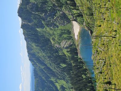
At the Lake: Straight Lake is a medium sized lake that does not get very much traffic. It is not as well-known as the Siamese and with no defined or maintained trail down to the lake it doesn’t see a lot of people during the summer; I doubt 10 people visit it in any given summer. There was a decent place to camp in the trees between the main lake and its sister pond in 1999, but was unable to find anything in 2025. 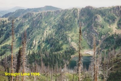 The fishing was good for Cutthroats. Much of the shoreline is brushy, but I was able to find several places to cast my fly. The outlet and inlet areas are open and provide some good casting options. There are trails around the lake but they are in poor condition. I was unable to completely circle the lake due to the cliffs on the west side of the lake.
There just isn’t an easy way into Straight Lake unless you ride a vehicle into Fish Lake, even then it’s not an easy hike. Coming in from Hoodoo pass is the most scenic but is also a very dry hike and is a solid 13 miles. Unless you park one vehicle down on Lake Creek, this is an out and back trip.
 I did this out & back route with my son to the Siamese Lakes, and we stayed at Pearl Lake going in and the Upper Trio Lake coming back. Coming in via Fish Lake or Goose Lake is at least 11 miles. If you plan on completing the hike in one day you start at either trailhead at 4,500 ft, and get to a high point of 7,300 during the day on either route. The 5.5 miles from Fish Lake is generally uphill.
A good way to visit this lake is to stay a couple nights at the Upper Siamese Lake and then complete a day trip for some fishing. A teacher I knew in Superior indicated that he used to come up the ridge from the Goose Creek trailhead. That was more than 30 years ago and with the growth of brush this might be a hard hike.
Loop Consideration: I have not completed this loop as one continuous trip, but have hiked all the trails involved. It would be easy to leave your vehicle at the picnic area at the Goose/Lake Creek intersection and then complete a loop up Goose Creek to Goose Lake and then come out via the Lake Creek Trail from Fish Lake. This would add 1 & 2 miles on each end of the trip for a 24-mile total.
Puddle Lake Option (See image depiction below): I have NOT physically completed this option into Straight Lake but have scoped it out in 2025. If you are hiking into Straight Lake from the North (Hoodoo Pass or Goose Lake) this would be a good option to reduce your milage by 1.5 miles and 400 feet of gain at the end of the day. As you are passing above Idaho's Lower Steep Lake look for a small tarn on the Montana side. This is Puddle Lake, per Joelle G. of the GBCA. Leave the stateline trail and work your way down to Puddle Lake, about a 150-foot drop. Stay right around the lake and angle down about 100 feet to a main game trail that traverses below the stateline. The trail is well defined and will lead you over to the bench / snowbank where you can connect in with the route previously described. The total distance of this option is 1/2 mile. Half that distance is some cross-country hiking and a bit steep in places; short and doable. The only bad thing is that you miss the very scenic high point above the Upper Steep Lake.


