Getting There: Take the Fish Creek Exit on I-90 and proceed up Fish Creek Road #343, then the right fork on road #7750 (Iowa State Research Center) that ends at the Clearwater Crossing in 6.75 miles. The clearwater crossing has a small campground (3 sites), 2 vault toilets and a Forest Service Guard Station. Take trail #103 (North Fork Trail) that takes off to the right of the Guard Station on an old road. Stay on this trail for about a half mile, the trail splits, with the North Fork Trail #103 heading up to hill to the right and Straight Creek Trail #99 staying straight along the creek. There is a sign at this junction.
 The trail (#99) up Straight Creek is just a tough go. It’s brushy and rocky. It doesn’t have too many steep sections, but it is at a grade almost all the way. Straight Creek Trail #99 continues along the creek bottom to the first of several creek crossings for the day. Cross the North Fork of Fish Creek and Straight Creek, they come together at this crossing. If you change out of shoes for the crossing, don’t bother putting your hiking shoes back on as there is another crossing of Straight Creek in less than a hundred yards. There are crossings at 2.5- and 3.35-mile markers.
After a little more than 5 miles you will come to what I have named the Staircase Falls, a good place to take a break as this is one of the few open areas to view back towards the Clearwater Crossing and up towards the stateline. There is a well-developed horse camp at the 6-mile mark. Another mile up the trail and another creek crossing or two you will get to a split in the trail. The left fork will continue as trail #99 and will take you up over Chilcoot Pass and down into the Lower Siamese Lake.
 At this point you need to stay straight and look for another crossing of Straight Creek to your right. This may require some searching as the crossing is not obvious. After crossing the creek, follow the trail until you cross the creek one more time, where the trail disappears. Head straight up the hill like you are going to Harrington Lake. There are a couple of big flat rocks just below the tree line.
Standing on them facing across the valley, look directly to your left (90 Deg) at the tree line; that is where the trail picks up again. Depending on how high the brush is, you might be able to see it. Follow this trail for about a mile to the headwall of Straight Lake. Make a hard left and climb directly to the dividing ridge, picking the route of least resistance and drop directly into the Upper Siamese.
This is an ugly way to end a long day on the trail, but I really like this route. I have completed it 3 times in my life, but it has been a while. An option here might be to take the Chilcoot Pass trail and then take the primitive trail from the Harrington Lake overlook directly up the dividing ridge to the Upper Siamese Lake. I have not hiked this trail in years and several fires have burned over the ridge during those years. So, as of this writing, I do not know the route’s condition and the effort involved.

Getting There:At Superior, take Diamond Road east past the Town Pump Gas Station for 6 miles; passing the Bark mill and the Magone Ranches to the end of the pavement where the road changes to Trout Creek Road (#250). Continue up Trout Creek Road (~19 miles) until you top out on Hoodoo Pass on the Idaho/Montana border. Take the stateline trail #738 for 4.5 miles to the split where the left fork heads down to the saddle between Pearl and Dalton Lake. Stay on #738 as it passes above Dalton Lake and heads up to 7,200 feet and a view of the Middle and Upper Trio’s. The trail then starts heading down to Goose Lake (5,800 ft), this is the first available water since Hoodoo Pass except for some possible snowbanks along the way.
The total distance to Goose Lake is a solid 7 miles. Goose Lake is the only easily accessible water source between Hoodoo Pass and the lake. There are small lakes/tarns on the Montana side, but they are a steep climb down. The water coming out of Goose Lake is not the best, it is a bit warm and has some taste to it. If you would like fresher water, then go over to the inlet stream on the other side of the lake or down the creek a hundred feet or so and filter the water there. Cross the outlet and take the left fork that continues up trail #738. The right fork, trail #414, will take you down Goose Creek to the trailhead there.
 After a couple of switchbacks the trail will line out towards the state line ridge, this is a bit more than a mile. The trail then heads steeply up the ridge, an ugly climb with a full pack. However, if you look to the left there is a trail that sidehills around this steep part and connects back up with the main trail.
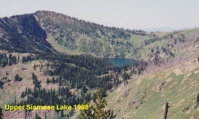
At the 2 mile mark the trail climbs gently to a rocky point, the is a good spot to take a break and really look around. This is a spectacular viewpoint where most of the northern half of the Great Burn is visible. You can look back to Hoodoo Pass and beyond to Illinois Peak, Crater Mountain dominates to the left and you are looking directly down Straight Creek toward the Clearwater Crossing in the West Fork of Fish Creek.
The trail continues along the state line alternating from Montana and Idaho for another 3 miles, passing by the appropriately named Upper and Lower Steep Lakes on the Idaho side of the ridge. Continue past Straight Lake about 1 mile to the saddle above the lake and take the unnamed trail (1/4 mi) down to the Upper Siamese Lake.

Getting There: At Superior, take Diamond Road east past the Town Pump Gas Station for 6 miles; passing the Bark mill and the Magone Ranches to the end of the pavement where the road changes to Trout Creek Road (#250). Continue up Trout Creek Road (~19 miles) until you top out on Hoodoo Pass on the Idaho/Montana border. Continue on Road #250 into Idaho for about 11 miles. About a tenth (0.1) of a mile before crossing the Middle Fork of the Clearwater River, road #250 crosses Long Creek and stays left of the Clearwater River. If you cross the river and get to the Cedars Campground, you have gone too far. Stay on road #250 for another half (.5) mile then stay left on road #295 up Lake Creek for about 4.5 miles. There will be a picnic area / trailhead with a vault toilet at the intersection. The left fork (road #5450) goes for a mile to a gate and the trailhead to Goose Lake and Steep Lakes; the right fork continues up Lake Creek for 1.5 miles to the trailhead for Fish Lake. Road #295 becomes trail #419 at that point, well it is still a road.
Stay on this well-defined trail for 6 miles to Fish Lake, the largest lake in the Great Burn area. Trail #419 moderately climbs up the valley crossing two creeks (Siam & Japanese) with just the middle couple miles a bit steeper, so it is easy to make good time.
At the second outhouse, there is also signage, head up to the left on trail #738 to the state line, where you will intersect trail #101 that leads down into the West Fork of Fish Creek and eventually to the Clearwater Crossing.
Trail #101 heads down into Foley Basin and connects with the trail (#114) that leads to the Lower Siamese Lake. Turn left at this junction with trail #101 and head North on trail #738. The trail climbs steeply for a bit before traversing around the hillside and providing some great views of the upper portions of the West Fork of Fish Creek. At the 1.1-mile mark (just as the trail steeply climbs) on #738 from Fish Lake there is an obvious side trail to the right which leads to a small lake (W Fork Fish Creek Lake 2) where water can be filtered. After about 3.0 total miles from trail #101 junction an obvious trail takes off from the saddle directly above the Upper Siamese Lake; it is about a 1/4 mile down to the lake on a sometimes steep and rocky trail.

Getting There: Take the Fish Creek Exit on I-90 and proceed up Fish Creek Road #343, then the right fork on road #7750 (Iowa State Research Center) that ends at the Clearwater Crossing in 6.75 miles. The clearwater crossing has a small campground (3 sites), 2 vault toilets and a Forest Service Guard Station. Cross the West Fork of Fish Creek on the stock bridge to pick up trail #101. Follow trail #101 for 9.25 miles to Foley Basin where trail #114 to the Lower Siamese intersects.
Along the way you cross the West Fork at mile 3 where you intersect trail #110 coming out of Cedar Log Creek and a camp site and swimming hole is just 100 yards from the crossing. The bridge is old, it has been there in excess of 50 years as I remember it back then. Nowadays a single hiker can make the bridge flex by just walking across so it might be gone in a few years. At five miles the trail (#121) out of Indian Creek crosses the West Fork and connects with trail #101.
At Foley Basin the left fork (#101) climbs up to the stateline and Fish Lake with the right fork #114 heading to the Lower Siamese Lake. There used to be a couple of good camp sites here at the junction, but unsure in 2025. From Foley Basin stay straight on trail #101 climbing about a mile to the Stateline Trail #738 above Fish Lake. Head North on trail #738 as it climbs briefly before traversing the mountain and providing good views of the West Fork of Fish Creek below. At the 1.1-mile mark from the junction with Trail #101 out of the West Fork of Fish Creek (just as the trail steeply climbs) on #738, there is an obvious side trail to the right which leads to a small lake (W Fork Fish Creek Lake 2) where water can be filtered. This is also a good place to take a break before tackling a hard section. After about 3.0 miles of mostly uphill travel from the junction of trail #101, you will arrive above the Upper Siamese Lake; take the prominent rough & rocky trail that winds down to the lake.
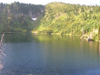
At the Lake: The Upper Siamese Lake is a good-sized lake with Cutthroat Trout. There are several good camping sites where the trail from the stateline comes down to the lake, directly on the little peninsula; and I believe one on the other side of the outlet. The shoreline is mostly accessible around the entire lake. The fishing has always been very good. Plan on spending more than 1 night here, it is well worth it. A day hike to Straight Lake or the Lower Siamese Lake is a great way to spend your off day; otherwise spend the day fishing around the entire lake or lounging on the edge of the lake in the sun are also great options.
Loop A Consideration: I have not completed this loop in one continuous trip but have hiked all the trails at some point. It would be easy to leave your vehicle at the picnic area at the Goose/Lake Creek intersection and then complete a loop up Goose Creek to Goose Lake and then come out via the Lake Creek Trail from Fish Lake. This would add 1-1.5 miles on each end of the trip for a 24-mile trip.
Loop B Consideration: Start at the Clearwater Crossing, take the West Fork of Fish Creek Route and then come out Straight Creek, taking the primitive ridge trail down to Chilcoot Pass. I have done this general loop a couple times in reverse; except I took the primitive sidehill trail from the upper lake to the lower lake (instead of the ridge) one time and went all the way around to the West Fork trail above Fish Lake on another trip. The route down the ridge is not for the faint of heart, it is a very tough go on a very primitive trail. Fires have eliminated all the shade on the ridgeline to Chilcoot Pass.