
Getting There: At Superior, take Diamond Road east past the Town Pump Gas Station for 6 miles; passing the Bark mill and the Magone Ranches to the end of the pavement where the road changes to Trout Creek Road (#250). Continue up Trout Creek Road (~19 miles) until you top out on Hoodoo Pass on the Idaho/Montana border.
Take stateline trail #738 for 4.5 miles to the split where the left fork heads down to the saddle between Pearl and Dalton Lake. Stay on #738 as it passes above Dalton Lake and heads up to 7,250 feet and a view of the Middle and Upper Trio’s. Proceed down the trail for about 1/3 mile to another overlook of the Upper Trio Lake. To your left is a marginal trail that angles down to the basin and stream that empties into the Middle Trio.
 The trail is well defined at the start but tends to fade out in the basin. Follow the least path of resistance along the stream and take a shallow angle towards the outlet of the Upper Trio Lake. Don’t drop into the lake too soon as it is very steep in places. It’s best to stay on the ridge longer than you think is necessary. Even though the distance is a bit over 7 miles, it is a hard route as there are significant elevation changes across the state line trail and water is not readily available. If it is a hot day, the hike can be pretty hard.
Getting There: At Superior, take Diamond Road east past the Town Pump Gas Station for 6 miles; passing the Bark mill and the Magone Ranches to the end of the pavement where the road changes to Trout Creek Road (#250). Continue up Trout Creek Road (~14 miles) to the Heart Lake Trailhead. There is a vault toilet and parking for over 20 vehicles.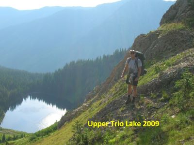 Trail #171 takes off on the far side of the parking area. The trail wanders through the bottoms, gradually climbing up the valley for 2+ miles. Then the trail turns up the hill and climbs much steeper for the next 3/4 mile to Heart Lake. Cross the outlet onto trail #175 and continue around Heart Lake to the far end. The trail continues to climb and switchbacks up the hill for 1 mile to Pearl Lake. Continue around Pearl Lake to the low saddle overlooking Dalton Lake. Turn right and follow the trail up the ridge to the stateline trail #738.
There is a little bit of a break above Dalton Lake but then the trail continues to climb to the high point of 7,250 ft. From this high point, proceed down the trail for about 1/3 mile to another overlook of the Upper Trio Lake. To your left is a marginal trail that angles down to the basin and stream that empties into the Middle Trio.
The trail is well defined at the top but tends to fade out in the basin. Follow the least path of resistance along the stream and take a shallow angle towards the outlet of the Upper Trio Lake. Don’t drop into the lake too soon as it is very steep in places. It’s best to stay on the ridge longer than you think is necessary. This route is a bit longer than the Hoodoo Pass route with water available at least to Pearl Lake but you are climbing steadily (2,600 ft) for 6 miles. Kind of a pick your poison when hiking from the Trout Creek side. The hike from Heart Lake to the high point is a bit of a grind if completing it in a day with a full pack.
Getting There: Take the Fish Creek Exit on I-90 and proceed up Fish Creek Road #343, then the right fork on road #7750 (Iowa State Research Center) that ends at the Clearwater Crossing in 6.75 miles. The clearwater crossing has a small campground (3 sites), 2 vault toilets and a Forest Service Guard Station. Take trail #103 that takes off to the right of the Guard Station on an old road. After a mile the trail splits with trail #103 going to the right and uphill. The Straight Creek trail #99 continues straight along the creek. Stay on this trail for about 11.5 miles passing the Greenwood cabins and crossing French Creek over that span. There is plenty of water along almost the entire length of the trail.
About a 1/4 mile before Goose Lake, there is an un-signed trail (#338) that takes off to the right. About halfway to the Lower Trio Lake you will cross the outlet for the Upper Trio Lake, look for a good trail a little past the creek that heads up the hill to the left. There is no signage, but the trail is there and easy to follow.
The North Fork trail is not too bad, it is well maintained and is a gradual climb up the valley until the last couple miles from Fletcher Gulch. Of the trails starting at or near the Clearwater Crossing, it is usually in the best condition.

Getting There: If you don’t mind taking a bit longer drive. At Superior, take Diamond Road east past the Town Pump Gas Station for 6 miles; passing the Bark mill and the Magone Ranches to the end of the pavement where the road changes to Trout Creek Road (#250). Continue up Trout Creek Road (~19 miles) until you top out on Hoodoo Pass on the Idaho/Montana border. Continue on Road #250 into Idaho for about 11 miles. About a tenth (0.1) of a mile before crossing the Middle Fork of the Clearwater River, road #250 crosses Long Creek and stays left of the Clearwater River. If you cross the river and get to the Cedars Campground, you have gone too far. Stay on road #250 for another half (.5) mile then stay left on road #295 up Lake Creek for about 4.5 miles. There will be a picnic area / trailhead with a vault toilet at the intersection. Take the left fork road #5450 for about 1 mile and park at the turnaround at the gate. The first mile of the trail is the continuation of the road, the road eventually narrows down to a trail. The trail rises gently with the only extended grade in the 1/2 mile around the Steep Creek crossing and last mile after passing through the meadows. The trail through the meadows can be a bit difficult to follow, but the trail runs fairly straight across each meadow.
I found in 2024 that there was a lot more brush than in the past; a lot of waist and occasional head high brush. If it has recently rained or is raining, it will be a wet hike (it was). The distance to Goose Lake is about 5.75 miles. There is plenty of water (~ 6 small crossings) on this trail so there is no need to carry water for the entire route as you do on some sections the State Line Trail. Once at Goose Lake follow the trail past the lake over the stateline and head down the North Fork Trail (#103) of Fish Creek for about 1/4 mile where a good trail, #338 splits off to the left; the North Fork Trail #103 continues down the hill. This intersection is NOT signed. Trail #338 meanders through the trees for almost a mile until you cross the outlet creek for the Upper Trio Lake. The Upper Trio Lake trail takes off left and up the hill just 100 feet from this stream crossing; with trail #338 straight to the Lower Trio Lake as Skye is indicating below.
 There is no signage, but in 2025 the trail was quite visible and easy to follow to the lake.
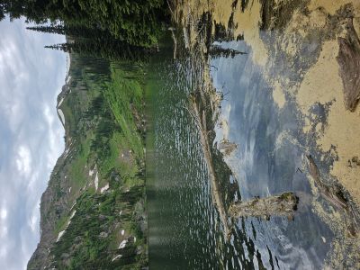
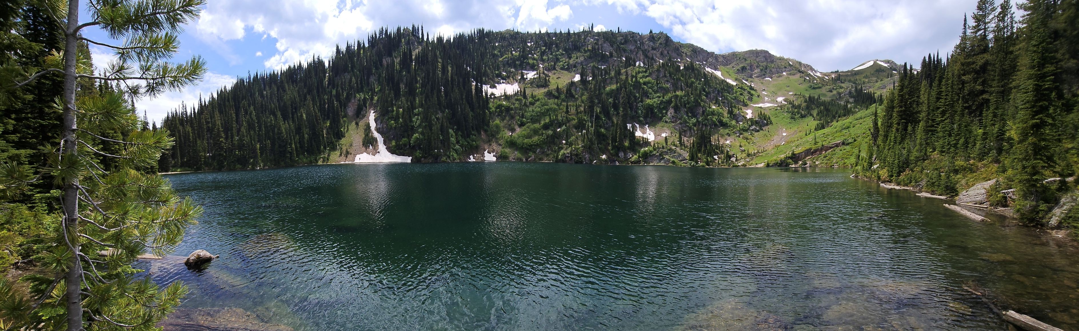
At the Lake: The lake has a nice flat campsite on the bench above the outlet, that seems to be the only established campsite. There are some smaller fish in the lake, but access around the lake is limited due to the steepness of the shoreline and brush. If you want to get away from everyone, this is the lake as there is little traffic. When Colter and I camped at the lake in 2009, we woke up to a deer having a meltdown a few feet from the tent. He was snorting and stomping because the tent was freaking him out. Kathy & I camped in 2016 but it was an uneventful night as far as the deer go.
With a little bit of effort, a person could visit all three Trio lakes in one day. The Middle Trio Lake is just over the low saddle between the lakes. There is a primitive/game trail over that saddle, the trail may take some searching to find. This is one of the few lakes along the state line that you probably will not see anyone outside of your party.