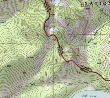
Getting There: At Superior, take Diamond Road east past the Town Pump Gas Station for 6 miles; passing the Bark mill and the Magone Ranches to the end of the pavement where the road changes to Trout Creek Road (#250). Continue up Trout Creek Road (~19 miles) until you top out on Hoodoo Pass on the Idaho / Montana border.
Continue on Road #250 into Idaho for about 11 miles. About a tenth (0.1) of a mile before crossing the Middle Fork of the Clearwater River, road #250 crosses Long Creek and stays left of the Clearwater River. If you cross the river and get to the Cedars Campground, you have gone too far. Stay on road #250 for another half (.5) mile then stay left on road #295 up Lake Creek for about 4.5 miles. There will be a picnic area / trailhead with a vault toilet at the intersection.
 The left fork (road #5450) goes for a mile to a gate and the trailhead to Goose Lake and Steep Lakes; the right fork continues up Lake Creek for 1.5 miles to the trailhead for Fish Lake. Road #295 becomes trail #419 at that point; okay it is a road. Stay on this well-defined route for 6 miles to Fish Lake, the largest lake in the Great Burn area. Trail #419 moderately climbs up the valley crossing two creeks (Siam & Japanese) and several other small creeks with just the middle couple miles a bit steeper, so it is easy to make good time. Once you cross the 350+ foot boardwalk you are about 1/2 mile from the lake.
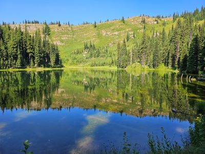
 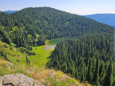 At the second outhouse as you just arrive at Fish Lake, head up to the left on trail #738 to the state line. There is signage at this intersection. It is about a 1/4 mile up to the stateline where you will intersect trail #101 that leads down into the West Fork of Fish Creek and eventually to the Clearwater Crossing.
Trail #101 heads down into Foley Basin and connects with the trail (#114) that leads to the Lower Siamese Lake. Turn left at this junction with trail #101 and head North on trail #738. The trail climbs steeply for a bit before traversing around the hillside and providing some great views of the upper portions of the West Fork of Fish Creek. At the 1.1-mile mark (just as the trail steeply climbs) there is an obvious side trail to the right which leads to W Fork Fish Creek Lake 2 in less than a 1/2 mile.
Getting There: Take the Fish Creek Exit on I-90 and proceed up Fish Creek Road #343, then the right fork on road #7750 (Iowa State Research Center) that ends at the Clearwater Crossing in 6.75 miles. The clearwater crossing has a small campground (3 sites), 2 vault toilets and a Forest Service Guard Station. Cross the West Fork of Fish Creek on the stock bridge to pick up trail #101. Follow trail #101 for 9.5 miles to Foley Basin where trail #114 to the Lower Siamese intersects.
 Along the way you cross the West Fork at mile 3 where you intersect trail #110 coming out of Cedar Log Creek and a camp site and swimming hole is just 100 yards from the crossing. The bridge is old, it has been there in excess of 50 years as I remember it back then; nowadays a single hiker can make the bridge flex by just walking across so it might be gone in a few years. I believe the bridge is scheduled to be replaced in 2026. At five miles the trail (#121) out of Indian Creek crosses the West Fork and connects with trail #101. The trail continues up the valley to Foley Basin at a moderate grade with a steeper grade around the couple switchbacks after passing by the creek coming out of the Siamese Lakes.
At Foley Basin the left fork (#101) climbs moderately up to the state line and Fish Lake in a little more than a mile. The right fork is trail #114 to the Lower Siamese Lake. Once on the stateline, turn right at the intersection of trails 101 & 738; there is a sign at this intersection. The trail climbs steeply for a bit before traversing around the hillside and providing some great views of the upper portions of the West Fork of Fish Creek. At the 1.1-mile mark (just as the trail steeply climbs) there is an obvious side trail to the right which leads to W Fork Fish Creek Lake 2 in less than a 1/2 mile.
At the Lake: W Fork Fish Creek Lake 2 is a small shallow fishless lake much in the same vein as Frog or Mud Lakes. There is a stream feeding the lake from the basin above that would be better for filtering than the lake itself. I found some remnants of a campsite / fire ring in the meadow by the lake. Although, this wouldn’t be my first choice for camping, it is a convenient place to take a break and let your furry co-hiker take a dip.
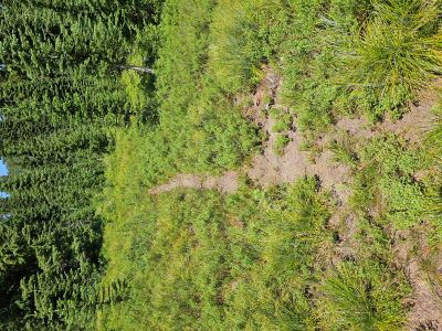
If coming from the North. As you pass above W Fork Fish Creek Lake 2, the trail will do a couple steep switchbacks down an open slope, then swing east into the trees towards the lake and level off a bit. Look for a primitive trail to the left just before you continue steeply down the ridge and below the level of the lake. It is a 0.1-of-a-mile, mostly-level walk across this lightly brushed flat where you connect with the trail that comes up from below.