Getting There: Take the Fish Creek Exit on I-90 and proceed up Fish Creek Road #343, for approximately 16 miles and turn right on Surveyor Creek Road #7734 for 12 miles to the Schley Mountain Trailhead. This is a rough 12 miles, especially the portion past the Surveyor Lake trailhead at 8.5 miles. The Schley Mountain Trailhead has several places to camp and park along with a vault toilet. This trailhead and campground are dry, so bring plenty of water if camping. This is not the actual end of the road. The gate is only open from when the snow is off until August 31; the gate is not open over Labor Day weekend.
 The road behind the gate is designated by the Forest Service as a non-maintained road. The Forest Service does not maintain or brush out this road. If you are the first one through the gate in the summer, then expect to saw out the downed trees from the winter storms if you want to drive the 3 miles to the end of the road and the old trailhead. The road is pretty good until you reach the 2 switchbacks, and the road gets decidedly worse from there for the last mile. Pullouts are a bit scarce so someone may have to back up a way when meeting another vehicle. The trailhead has plenty of room for parking and several camping sites; the ridge trail from Schley Mountain connects back to the road. The road continues beyond the gate.
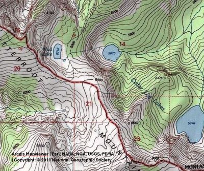
 Hike this road, bearing left and up after 1/3 mile; the stateline and trail number #738 is about 1 mile from the trailhead. Once on the stateline stay on the main road / trail that heads north with great views of the Kelly Creek drainage with Shale Mountain and Rhodes Peak in the background. The road / trail will split again at the 2-mile mark with the right fork continuing to the South (Big) Cedar Log Lake and the left down to Kid Lake in a 1/2 mile. Head down to Kid Lake, cross the outlet where the main Kelly Creek Trail #567 connects and continue up the hill past Kid Lake.
The trail winds uphill from Kid Lake to the stateline. This is a rough and rocky trail that culminates with a steep pitch for the last couple hundred feet to the saddle and stateline. The stateline is a bit flat here and although it seems like you have crossed over into Montana, the trail follows the stateline down the hill until almost to Mud Lake a mile later. Here, the stateline trail heads to the left (North) and up towards Admiral Peak and eventually to Vann and Fish Lake. Trail #104 continues down to Mud Lake. The total distance to Mud Lake is 4.5 miles from the trailhead.

At the Lake: Mud Lake is little more than a pond with frogs, snakes, and mosquitos. There are several good camping sites around the lake and amongst the trees. You have a good chance of seeing Elk, Moose or Deer here. A couple we met at the trailhead talked about how the deer were not afraid of them at all and hung around camp that evening and during the night. The North (Little) Cedar Log Lake is just down the trail in less than a mile.