Getting There: Take the Fish Creek Exit on I-90 and proceed up Fish Creek Road #343, for approximately 16 miles and turn right on Surveyor Creek Road #7734 for 12 miles to the Schley Mountain Trailhead. This is a rough 12 miles, especially the portion past the Surveyor Lake trailhead at 8.5 miles. The Schley Mountain Trailhead has several places to camp and park along with a vault toilet. This trailhead and campground are dry, so bring plenty of water if camping. This is not the actual end of the road. The gate is only open from when the snow is off until August 31; the gate is not open over Labor Day weekend.
 The road behind the gate is designated by the Forest Service as a non-maintained road. The Forest Service does not maintain or brush out this road. If you are the first one through the gate in the summer, then expect to saw out the downed trees from the winter storms if you want to drive the 3 miles to the end of the road and the old trailhead.
The road is pretty good until you reach the 2 switchbacks, and the road gets decidedly worse from there for the last mile. Pullouts are a bit scarce so someone may have to back up a way when meeting another vehicle. The trailhead has plenty of room for parking and several camping sites; the ridge trail from Schley Mountain connects back to the road. The road continues beyond the gate.
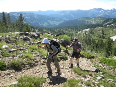
 Hike this road, bearing left and up after 1/3 mile; the stateline and trail number #738 is about 1 mile from the trailhead. Once on the stateline stay on the main road / trail that heads north with great views of the Kelly Creek drainage with Shale Mountain and Rhodes Peak in the background. The road / trail will split again at the 2-mile mark with the right fork continuing to the South (Big) Cedar Log Lake and the left down to Kid Lake in a 1/2 mile.
Head down to Kid Lake, cross the outlet where the main Kelly Creek Trail #567 connects and continue up the hill past Kid Lake. The trail winds uphill from Kid Lake to the stateline. This is a rough and rocky trail that culminates with a steep pitch for the last couple hundred feet to the saddle and stateline. The stateline is a bit flat here and although it seems like you have crossed over into Montana, the trail follows the stateline down the hill until almost to Mud Lake a mile later. Here, the stateline trail heads to the left (North) and up towards Admiral Peak and eventually to Vann and Fish Lake.
Trail #104 continues down to Mud Lake. Pass by Mud Lake and continue on trail #104 for less than 1/2 mile to the intersection of Indian Creek trail #121. Stay to the right on the un-signed trail that angles down the hill towards the lake, the trail is good all the way to the lake. Trail #104 continues along the ridge for several miles and eventually connects with Trail #101 in the West Fork of Fish Creek. I have no idea what the condition of this trail is. You would have to call the Ninemile Ranger District to find out when the trail was last cleared The Ninemile District does keep good records on the trail maintenance and annual clearing, they just need the trail number you are interested in.

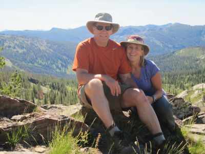
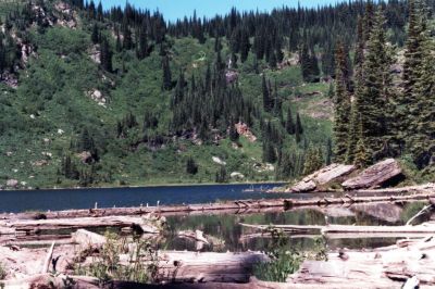
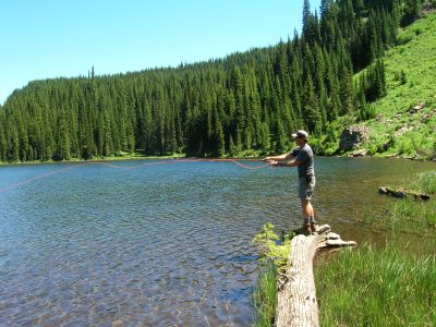
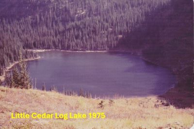
At the Lake: This is one of my favorite lakes along the stateline as it is a great hike in with lots of vistas of the Kelly Creek drainage and it is a little out of the way, so you might have the lake to yourself even on the weekends. The fishing is good for cutthroat trout and the shoreline is accessible around the entire lake. Swimming is also good as the lake is relatively warm for a mountain lake.
There are a couple camp sites just off the rock outcrop above the inlet stream and meadow. There are also 2 marginal sites on either side of the outlet. You have a very good chance of seeing game (deer, moose or elk) while at the lake. Moose are very prevalent in this area, I have seen as many of 5 moose at the lake in one day; 2 cows, a yearling calf, an immature bull, and a mature bull were all around the lake one summer day. My brother had to shoo a cow moose out of camp one night as she was right by the tent.
Alternative Route: Comment: I have not completed this route in several decades. We used to come into the lake from the South (Big) Cedar Log Lake. This route is tricky but takes more than an hour off the hike that goes around Kid and Mud Lakes. Hike around and cross over the outlet for the South (Big) Cedar Log Lake; see that lake description on getting there. Game trails wander through the trees and flat until you come to a meadow with a stream running through it. There can be loads of Huckleberries along this route. Remember where you come into the meadow for on the way back. The dividing ridge between the two lakes is directly above you. Look for a thin diagonal line of rock that points up to the ridge. Follow this line up to the ridge where you will find a game trail on the ridge. Depending on where you climb up the ridge you may have to go up or down a bit to find what looks like a very good trail diving off the ridge toward the North Cedar Log Lake.
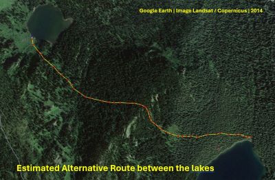 This trail comes and goes and is very brushy in spots, do not allow yourself to drop down the hill to your right as you may miss the lake altogether. After you cross a small creek, you can find a good game trail that will take you to the lake. If you are returning the same way this trail is important as it gets you almost halfway to the ridge without doing a lot of bushwacking.
I once took my nephew and his wife on this route and then took the trail back to Mud and Kid Lakes as a loop. It was a pretty good day. The way out is easier as you have a reference to start with. It is only a mile between the two lakes by this route. It took me several times to really know the proper route, it is not a clean and easy way between the lakes.
Potential Loop: A good loop trip would be to hike up the West Fork of Fish Creek Trail #101 from the Clearwater Crossing and camp at Fish or Vann or possibly the Lower Siamese Lake to end day one. Day two would be to hike trail #738 to Mud / North (Little) Cedar Log Lakes. For day three hike back to the Clearwater Crossing via Indian Creek trail #121 and the West Fork Trail #101. The trail down Indian Creek is in good shape and passes through some phenomenal cedar groves, there was a trail crew working the trail in 2024. Total milage for this trip is a little under 30 miles.