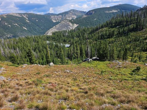
Leo, North & Middle Cache Lakes: My original plan was to spend a couple days (Weds-Fri) at the Middle Cache Lake; exploring around that area for the main Cache Creek trail. However, we were also leaving on Saturday for the Beartooths and Yellostone. It became apparent that I wouldn't be able to get unpacked and repacked in an evening so I opted for just an overnighter. I was pretty grumpy on the drive into the trailhead as it was spitting rain in Fish Creek and the state line didn't look good. By the time I got to the trailhead conditions improved and by the time I got 2 miles before the cross country portion the clouds cleared to a nice blue sky.
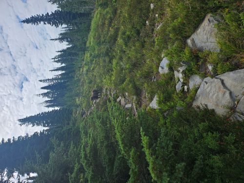
It was uneventful getting to the water stop and then on to Leo Lake. Last year I went over to Leo Lake and really suffered, totally played out by Leo. This year I made it to Leo easily. It was a lot cooler this year and I have more milage with this being my 3rd backpacking trip in as many weeks. I had lunch (Shelf 2 Table Meat Loaf) at Leo for an hour then pushed up over the saddle to North Cache Lake. I followed the same route that I used last year down to Middle Cache Lake. I took my time going in taking some longer breaks and not pushing the pace; so it took me over 6 hours in total. There are no established campsites at Middle Cache, I haven't found any, so I found a good place to pitch the tent. Skye and I called it early and headed for the tent before dark.
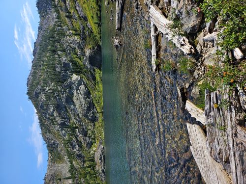
In the morning, we got up early, I had coffee and breakfast (Shelf 2 Table Egg Frittata); I have been trying out the Shelf 2 Table selections and finding that they are a pleasant change from Mountain House or Peak. I put the fly pole together and quickly caught a couple small cutthroats. I think the biggest one was 8-9 inches but I don't think they get much bigger. The Middle Cache Lake is not supposed to have fish according to the Montana Stocking records. I talked to a fishery guy in Missoula this spring and he was surprised that the lake had fish.
Skye and I then took a walk down below the lake to the left of the outlet and found what I am pretty sure is the old trail coming out of the main Cache Creek. We followed it down the hill for less than a 1/4 mile; it was very faint in places but visible. I was on this trail back in the 1980's and at that time was very prominent. We got going around 9:30 and headed up the hill. I decided to try a different route out. I headed straight up the hill, crossed the dry streambed from North Cache and aimed for the location where the primitive trail from North Cache peters out.
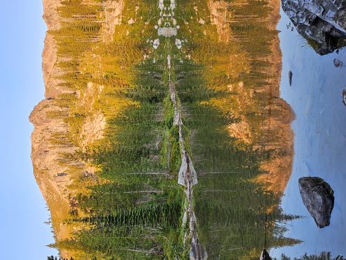
It was about a 45 minute climb out with a full pack so I felt good about that. I got some great pictures at North Cache Lake and then headed down to Leo. I did see a couple risers at Leo, so there is a natural population. I was going to have lunch at Leo but some early thunderstorms came rolling in. I was able to stay between 2 storms for a couple hours with just some minor hail. One storm I was following really hammered the area going over to Admiral Peak, just constant thunder, glad I didn't get caught in that as along with the lightning it just poured from the trailhead north. I did find the old trail that traverses from the water stop back to the head of the drainage; more detail on that below. All in all a good trip.


The Trail Over to North Cache Lake: A frequent question I get is if there is a trail all the way over to Leo Lake and beyond. The simple answer is "yes" there is a trail. However, there is a lot of context to go along with it as the trail is kind of faint and disappears in several places and there are no trail markers. Hence, I provide a general cross-country route to get to the water stop. It is kind like finding the Isla de Muerta from Pirates of the Caribbean; can not be found except for those that know where it is. You can actually see much of the trail on the 2014 Google Earth Imagery.
Here is a more complete description. With that, what follows is NO GUARANTEE FOR SUCCESS, especially if it your first time across to Leo. I have been over this route many times but can still have trouble finding the proper traverse route from year to year. From the trailhead head up to the stateline like you are going to Kid Lake. At the top of the state line (mile 1) look for an old road taking off to your left. Follow this grown in road to the overlook of Irish Creek where it turns into a single track trail. Follow this trail up the ridge until it swings around to the right and climbs up around the rocky point where it disappears in a meadow (mile 2).
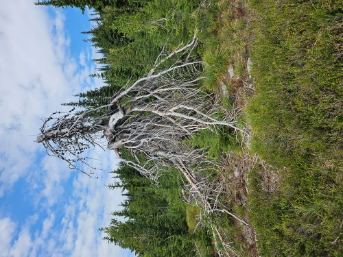
There is a trail that picks back up on the other side of the meadow on the edge of the ridge and down the hill a bit, but it is hard to find anymore, especially if you have never been that way. The way I go is to head across the meadow at about a 45 degree angle towards a narrow opening in the trees and then head straight down the steep hillside. You should intersect the old trail from the meadow on a bench in some trees. Follow that trail down to a gnarly old tree (see picture 1).
This is where things get a bit tricky. The trail you are on soon disappears but the good (sort of) trail that traverses over to the water stop is straight down the hill from this tree just on the other side of the shallow draw. Aim for between area shown in pictures 2 & 3, but you may have to do a bit of looking to find it. These old snags from the 1910 Burn used to be great markers for other marginal or off trail routes, but they are almost all long gone.
Back when we first started going into Leo and North Cache Lakes there was a very distinct old snag that marked the point well. That snag is long gone so there is a little more sleuthing needed. If you miss the trail, just keep traversing around the hillside, but don't let youself drop down the hillside. There is a point in a rocky area that the trail disappears, keep traversing and it will pick back up in a hundred yards or so. This is not a trail like on a lot of the state line. It is barely a foot wide at the most and is frequently covered by beargrass.
If you are able to follow the trail all the way to the water (no guarantee of that), you drop down a steep ridge to the water stop. The trail is much easier to find on the way out from the water, the trail goes straight up the ridge and then then levels out and traverses the hillside. The trail is much easier to follow on the way back. The water stop is about 3.25 miles in.
From the water stop the trail is really good in comparison. It heads along or near the ridge top for another couple miles to Leo Lake. There are 2 climbs on the ridge that can be hard if really tired. There has been someone with horses through this portion as some (not all) of the deadfall has been cut out since I went to Leo Lake in 2023.
To get to North Cache from Leo, follow the trail around to the right. You can see this trail cutting across the slope above Leo Lake. There is a small basin above Leo; cut across the basin stream to the left hillside. There is a very primitive trail that goes steeply up the left side to the saddle. The farther up the steeper and worse the trail becomes. In all the years (since 1981) that I have been over to Leo and North Cache Lakes, I have never seen anyone at these lakes.