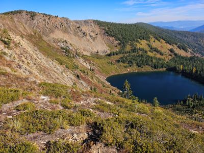
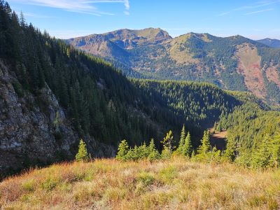
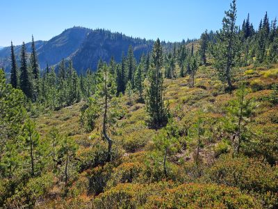
I decided on Wednesday to go ahead and return to Ward Peak Lake for a couple purposes. First, I wanted to solidify my description of the route to the lake. I think the route to Ward Peak Lake and the lake itself have a lot to offer eventhough fishing isn't an option; it has a good bang for the effort involved. Second, I didn't spend enough time exploring the area. I want to walk down the ridge to overlook Hazel Lake and possibly the valley below Ward Peak Lake. Third, wander down to Square Lake from the traverse trail and do some fishing. The route down to Square looks very doable, but I need to test that theory out.
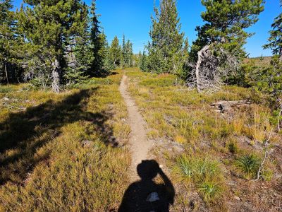
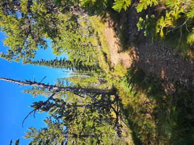
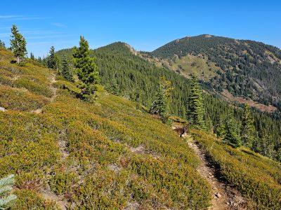
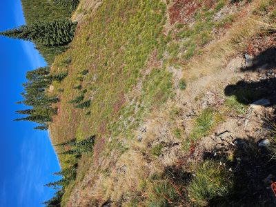
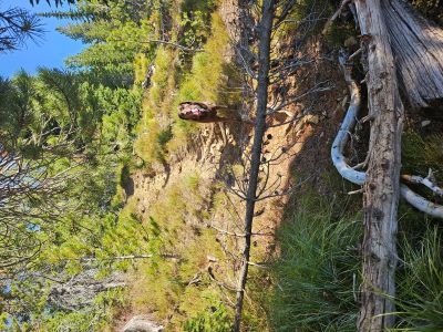
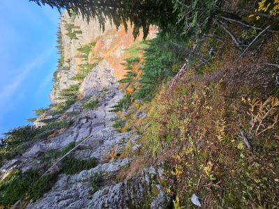
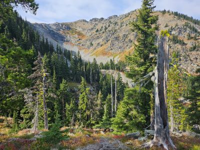
Ward Peak Lake: I got going out of the garage around 6 and was at the Square Lake trailhead around 8:30. The Little Joe Road is now open, it has been closed most of the summer as the Forest Service was building a cement bridge across the creek. From the Square Lake trailhead, I didn't walk far enough up the road before heading up the hill to the saddle, but I did run into the continuation of the Traverse trail on the way to the saddle. It is not as good as the rest of the trail, I assume it will go to the Square Lake trailhead but didn't follow that thought up. I didn't find anything really different with the trail over to Ward Peak Lake, but I will add some additional detail on the lake page.
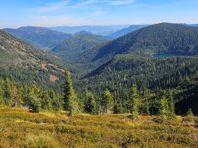
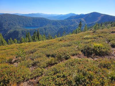
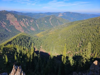
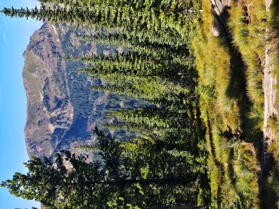
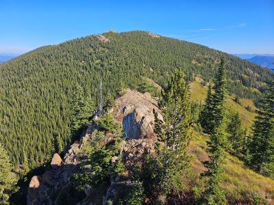
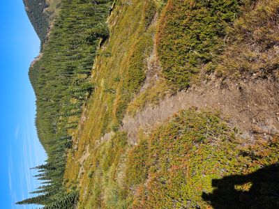
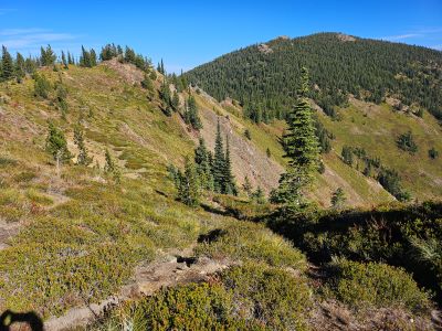
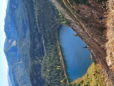
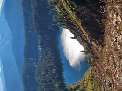
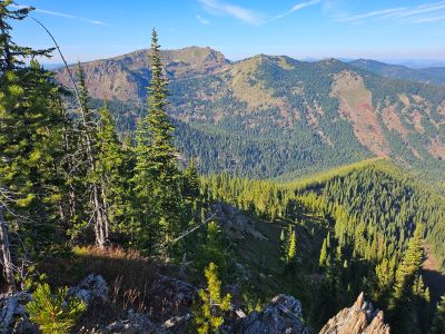
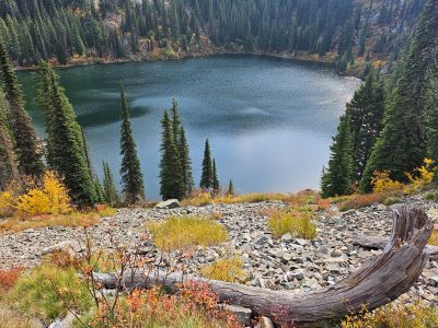
Skye & I stayed about 20 minutes at the lake, it is such a neat setting. From the trailhead to the lake takes about an hour; the trail just doesn't lend itself to a fast pace as you need to pay attention to the trail and the views are very nice. As we were leaving the lake, we heard a wolf howl in the distance but couldn't tell exactly where it was. That was the only howl we heard that day. We hiked down the ridge toward Hazel Lake, but reached a point that was very steep and we weren't gaining a better view as there were still lots of trees. Getting down to the valley below Ward Peak Lake would be a chore. I took a couple pictures and headed back up the ridge to the trail.

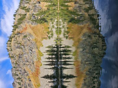


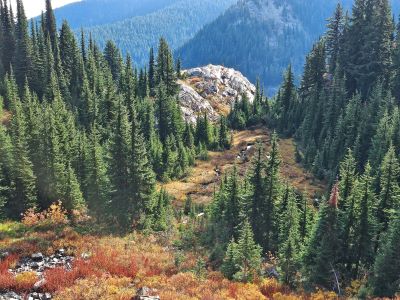
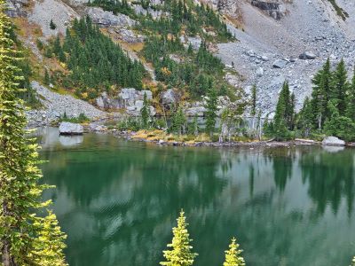


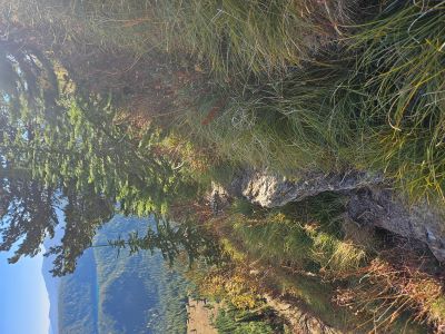
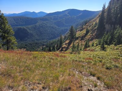
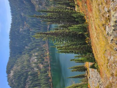
Square Lake: When I got back to the point above the steep climb up the draw, I went down through the rocks to the left coming out near the big log blocking the trail. I headed down through the dry draw; the one just left of the draw with the stream. This took me down through the trees and onto a steep open slope. I worked my way down to a good game trail that took me down to Square Lake. You end up on the far side of Square Lake from the inlet and the normal trail from the trailhead.
I am going to add this route to the lake page. This route is further than the main trail from the road, but was far more enjoyable. This side of the lake is free of the blowdowns that frequent the outlet area and going around the left side back to the main trail. There is a nice open campsite on this side of the lake. I put my pole together and fished for a bit but didn't have any luck at all. I gave serious thought to going back up the way I came in. I think that game trail will eventually connect back to the traverse trail or get close enough to make it a worthwhile alternative to the trail from the trailhead. I will have to check that out next summer.
The route around the left side of the lake to the inlet is still horrible, a 20 minute slog through the brush, across some swampy areas and over deadfall; lots of deadfall. The climb back up the hill to the trailhead hasn't changed much either. Even in October the lower half of the trail is wet and slick. It is not bad going up but is treacherous to come down. I made the road in about 30 minutes from the inlet.
I had other designs to head over to Newman Lake so we headed back along the road past bed springs to a point were the road is almost on the stateline. This is a point not too far from the road that comes out of 2-mile. Newman Lake is only about 1/3 of a mile from this point and I figured I would just angle over to it. I knew it would be steep but I didn't anticipate a dirt cliff loaded with brush and trees. I don't think I made it 200 yards from the truck in 30 minutes, what a hell-hole. I will have to re-evaluate a valid route down to this lake, probably taking a longer route from the other direction.


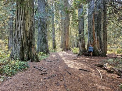
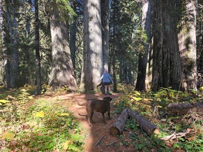
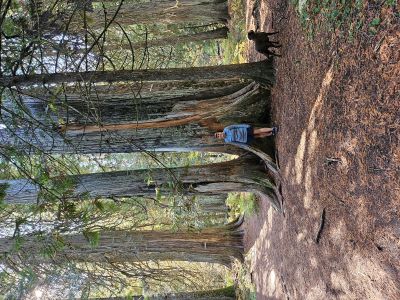
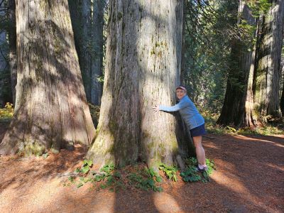
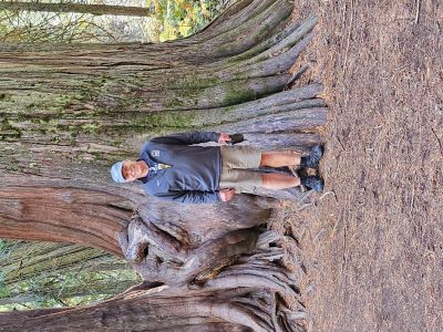
Ross Creek Cedars: On Sunday, Kathy and I took a drive to the Ross Creek Cedars and then returned via Thompson Pass. Instead of trying to write up a description for the grove, I will provide a couple links from other sites that do a great job describing it. Naughty Hiker: Ross Creek Cedars Loop and Inland NW Routes: Ross Creek Cedars Loop. I might be a bit lazy here but it is such a well known site.
There are several campgrounds in the area. Bad Medicine is just down the road. This is a nice (very basic) little campground (16 sites) with a day use area and boat launch to Bull Lake. The sites are limited in size so not all will accomodate a trailer or larger RV. We have stayed here a couple times after Labor Weekend. The other campground is down on Highway 200 at the mouth of the Bull River, it is a also a basic campground with a boat launch but is much bigger and will accomodate much larger trailers or RV's. We have never stayed there.

Lost Peak: On Monday, I headed over to Superior and up to Missoula Lake and Cascade Pass. The goal was to hike to the top of Lost Peak along the dividing ridge between Lost & Dry Creeks. Unfortunately, I did not make the summit. I didn't get a very early start and ended up starting the hike just before 9:30 Pacific, which really cut the daylight hours I had to work with. Starting at Cascade Pass I went north on Stateline Trail #738 towards the Bonanza Lakes. Continue on trail #738 at the junction of trail #616 that leads down to the Bonanza Lakes. After this junction the trail climbs intermittently until the high overlook to the Upper Bonanza Lake, a distance of 2.75 miles.
If you haven't been this way before, there are great views of both Bonanza Lakes. Hiking up the ridge to the right leads to a outstanding high point view in all directions, well worth the effort.
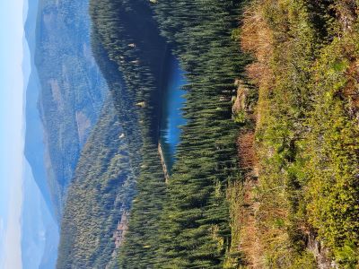
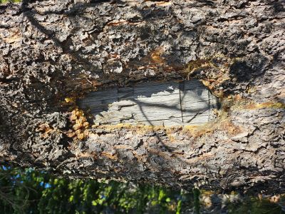
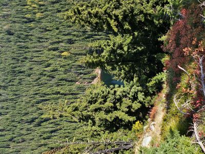
Back on trail #738, it heads downhill for a little over 1/2 mile where the unsigned & unnumbered trail to Lost Peak intersects. The intersection is at a point where the main trail heads straight down the hill and there is a blaze / arrow on a tree (see pictures). The trail is blocked but heads directly uphill to a point where it crosses over into the Lost Creek drainage (3.5 mi). There is a nice view of Lost Lake of which you will see a lot of on this hike.
The trail you are on heads down into the upper part of Lost Creek. Instead, go up the hill to your left for less than 50 feet where you will pick up another trail that will stay on the ridge most of the way over to Lost Peak. This is a primative trail that disappears at times on the ridge tops, so you may have to do some sleuthing. Due to the trees, the views over into the Dry Creek drainage and stateline north are limited, but outstanding where presented.
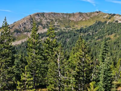
As you approach the taller ridge the trail will swing over to the left side in the trees and climb moderately up to a saddle of sorts on the ridge. It is about a mile along the ridge top to this point for a total of 4.5 miles. The trail heads straight down the hill and across the hillside. It loses 300 feet in a tenth of a mile and like me you will probably say something to the affect of "Oh Hell No, I'm not doing that".
The ridgeline looks inviting but its not the way to go. I hiked the ridge top to the left and that was a mistake. You eventually have to get off of it and it is actually steeper than going down the trail. I slipped, fell and banged my arm and elbow on a rock losing a couple chunks of skin and receiving a nice bruise in addition. I ended up sacrificing a bandana to halt the flow of blood from my elbow and arm. Skye also had a mishap, losing her grip and sliding 20+ feet on her butt down the hill before she could get herself stopped.
Google Earth, topo maps nor my photos give this ridgeline area enough justice. So "suck it up buttercup" and take the trail. The trail isn't a picnic either as it has a lot of loose dirt and rocks, so traction is important. The trail eventually ends up just under the low saddle before the final push to the summit so it works. We had lunch at the saddle and I finished cleaning up my wounds.
It's almost 600 feet to the summit from this point, probably a solid 1.5 hours to do the round trip from the saddle with limited time on top with an additional 3 hours back to the truck. As it was going on 1:30 by this time and it had already been a tough day, I decided to head on back. From the ridgetop and saddle there are great views of Lost Lake, Lost & Dry Creek drainages and stateline.
The 300 feet back to the ridge on that trail was tough, 15 minutes of using both trekking poles to pull and push me up the hill. It took about 3 hours to get back to the truck and the waiting beer. I will try again next summer. It is approximately 10.5 miles round trip that is totally dry if there are not any snow banks; I would plan on at least 8 hours for the round trip; this is not at all like the virtual stroll up to Illinois Peak.