Hoodoo Lake: I haven't been into Hoodoo Lake in several decades, so it has been on my list to try for a visit to update the trail description and get current pictures. I drove up Trout Creek Tuesday morning and set up camp at a campsite 0.85 miles down from Hoodoo Pass just off the road; a nice place in the trees. I hadn't been to Hoodoo Lake via trail #111 from Hoodoo Pass before so that was my route.
At Hoodoo Pass, take the state line trail #738 south on the old road for 1/2 mile and turn left on trail #111 on a sharp right hand switchback. There is a broken off sign post leaning against a tree but no sign. If you miss the junction, the old road will soon convert to a single track that traverses around the hillside. Trail #111 basically traverses around the hillside for about 1/2 mile with very little elevation change, this is a very pleasant walk. There is year round spring just as you are reaching the ridgeline above Hoodoo Lake. The trail then descends down the ridge for 1/2 mile to the junction with trail #111-A.
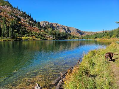
**The sign at the junction is completely wrong.** You are actually at trail #111-A, not 1/2 mile away; and the milage to the stateline trail #738 is actually 1.0 miles, not the 2.5 miles on the sign. I believe this is a sign that should be at the other trailhead. Head down the hill and Hoodoo Lake is less than 1/2 mile from the junction; the trail is an easy walk to the lake.
This route is about 1/2 mile longer than the than the route from the "Big" corner, but is not as steep. I didn't have any need to take a break on the way back to the Hoodoo Pass trailhead. I spent some time at the lake walking some around both sides of the lake from where the trail comes in. I only saw one campsite to the left of the outlet. I suppose most people do not camp, just day hike in. There were quite a few risers while I was there.


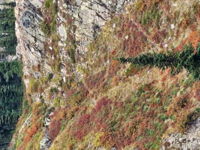
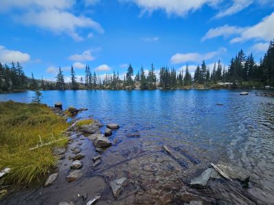
High Point Above Dalton Lake: On Wednesday morning I got up early, broke camp and headed down to the Heart Lake Trailhead. The goal for the day was the high point directly above Dalton Lake. There were just 2 other vehicles at the trailhead. The fall colors are coming on really well as noted by pictures of Heart and Pearl Lakes. Not quite as grand as last year in October but still very nice.
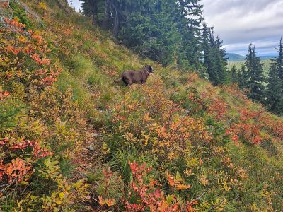
There was a tent at the campsite by the outlet at Pearl Lake but nobody around. I ran into the occupants just as I was hitting the stateline trail #738 above Dalton Lake, an older couple from Plains. They had taken a hike up to the high point along the stateline trail, but I was heading over to the left from that vista. They commented that they had a band of goats hang around their camp the day before. The goats were not acting very wild and a couple were a bit aggressive, not a relaxing experience. Kathy and I had the same experience at Pearl back in 2016 when 14 goats hung around our camp all day. When I first started exploring the stateline country it was rare to see goats.
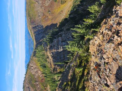
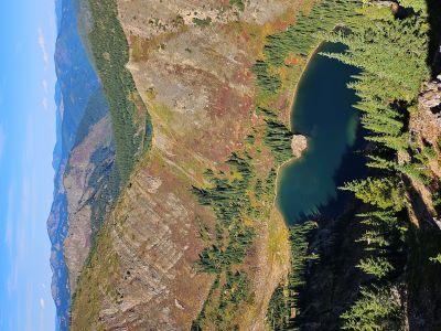
Not long after, I left the stateline trail and picked up a goat trail hugging the edge of the cliffs above Dalton Lake. I made my way along the ridge tops to the high point at about 7,100 feet. The views from this point are pretty spectacular; with a unique view directly down to Dalton Lake and other great vistas in all directions. All three Trio Lakes are visible, but you have to walk down the ridge 100 feet or so to see the Middle Trio Lake. Crater Mountain dominates to the South and the basin below that houses the Trio Lakes is completely visible. You can even see part of Pearl Lake past the low saddle above Dalton Lake.
Skye and I stayed for almost an hour and had lunch before we worked our way back along the ridge to the main trail and out past Pearl and Heart Lakes, a 12 mile total for the day. We didn't meet anyone besides that couple the entire day, but watched a pack string climb out of Pearl and head over towards Goose Lake while on the summit. Overall, the day was great with very nice weather despite a storm system moving in later in the day; it was quite windy on the ridgetops.


Ward Peak Lake: After a Thursday recovery day, Skye and I headed up to Ward Peak and its namesake lake below on Friday. Last year I scoped out this lake and a possible route down to it. The ridge down to the lake is steeper than hell with cliffs along the left side. This would be a very hard hike in and out as it is very steep. I have seen a brief description for this lake on the Inland NW Routes website; in which there is a mention of a hunter's trail that leads to the lake.
Starting at the Ward Peak Trailhead (trail #250) on the Stateline Road #391. Instead of going straight up the hill from the trailhead to the ridge that drops into the lake, I took the old trail that leaves the main trail (#250) and heads to the East around the mountain. This trail is about 1/4 mile up the main trail #250 to Ward Peak and heads opposite of trail #250. This trail is visible on Google Earth, use the 8/2014 imagery as it has the best resolution. I was thinking that this trail could connect with the Hunters Trail that Chic & Dave described on their website; in a round about way it does. The trail traverses around the mountain to the Southeast side but then deteriorates and eventually ends at the remains of an old cabin below a rockslide.
From the cabin site, I then traversed East over to the ridgeline/stateline that overlooks Square Lake. From this vantage point I could see the trail below that was described on the Inland NW Routes website. I continued SouthEast down the ridge to a low saddle where I found the trail where it meets the ridge. The trail dives steeply off the ridge for about 50 feet before traversing NorthWest towards Ward Peak and the lake. I would wear something with good ankle support as a lot of the trail is sloped off at 10-30 degrees.
The trail is rugged but fairly easy to follow most of the way as there are some cut logs and trees; there are some downfalls that detour or interupt the trail. The only place I got tripped up is where the trail briefly climbs straight up the hill for 100 feet, see Pic #1. It is hardly visible and a better trail continues straight to a rocky area where it disappears. There was a rock cairn there which led me away from the actual trail. I eventually figured it out but had to climb back through the rocks to find the trail again.
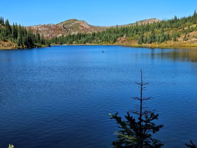
The trail will take you to gentle saddle at the base of the steep ridge and head over to the lake, about 200 yards. The lake was very nice; I was wishing for a warmer and less windy day for a swim. Skye and I walked around the lake and crossed the narrow spot, took a bunch of pictures and had lunch. It is a very nice setting. There is a small campsite just below the lake. We even saw a Bald Eagle.
On your way (200 yards) out climb up the ridge to the left a bit where you have a good view of Hub Lake and Eagle Peak towering above. I was hoping to possibly see Hazel Lake but I wasn't willing to go that far down the ridge. To get to the lake (see the Ward Peak Lake page), I would start at the Square Lake trailhead, walk up the road about 1/3 mile and then head straight up the hill to the saddle and where the "Traverse Trail" takes off. I did not find a good trail from that saddle down to the road. It is less than a mile from the road to the lake. It is a rugged and sometimes primitive trail with a rewarding end that does take some patience, so don't be in a big hurry.
It took me less than 45 minutes to get back to the road from the lake and less than an hour to the truck parked at the Ward Peak trailhead.