
Getting There: The best route to get to the trailhead is to take the Little Joe Road (#282) out of St. Regis and then take the state line road (#391) at the Idaho / Montana summit. Follow this road for approximately 5.5 miles. The trailhead is about a mile past the Square Lake trailhead. The trailhead for trail #250 is on the shoulder of Ward Peak and has signage. There is a wide spot just back from that point or you can park at another pullout just down the road.  There is another road from the Idaho side that connects just down from there to turn around.
The state line road (#391) gets considerably narrower and rougher at that point. If you are tempted to follow the road out to eventually get to the Hiawatha Trail, make sure you have a couple hours to spare, a servable spare tire and a chainsaw. The road is very rocky and low-slung cars are not recommended. Razers, jeeps and side-by-sides use the road and do not cut out the deadfall to standard truck width so you may have to cut out an opening to get your truck through. I have seen cars on the road, but I wouldn’t take one.
Take the Ward Peak trail (#250) and stay to the right (upper) at the trail split. The lower trail (#250) is the Up Up Mountain ridge trail that will take you over Eagle and Gold peaks and eventually to the road to Up Up Lookout. The upper trail is not numbered and will take you to the summit of Ward Peak.
 At the point that this upper trail connects with the ridgeline and turns back to the Ward Peak summit; leave the trail and head down the ridge toward the low saddle between Ward and Eagle peaks. There is a primitive trail of sorts along the ridge, but I would consider this a cross-country venture the rest of the way to Mary Lake. You’ll be able to see the lake the entire way.
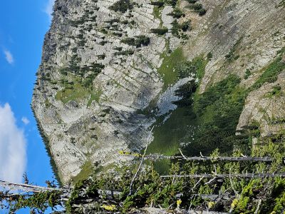
 When you get to the dividing ridge between Mary Lake and Hub/Hazel lakes dive off there and find the best route you can take down to Mary Lake. There is no trail, and it is steep. It is tempting to try and stay on the rocky ridge, but it seemed that there would be some places that would be more difficult than the green draws that lead to the lake.
Getting There: Take the Ward Creek Road (#889) exit off I-90. The exit is only accessible from the East bound lanes and sits right on a sharp corner, if not paying attention you could miss it. Drive approximately 6 miles to a switchback and bridge across Ward Creek where there is a sign for the trailhead and ample parking. Hub Lake 2022Stay on the main road, you will pass the road that leads to Up Up Lookout at mile 3. The lookout is rentable, but not recommended for small children for safety reasons.
 Trail (#262) starts out meandering through the bottoms and some cedar groves. The trail climbs moderately and after a mile or so you will get to a nice set of waterfalls that are far below the trail. It is a very steep climb down to them but worth it. The trail splits shortly after the falls with trail #262 turning left steeply up the hill and back towards the state line; there is (was) a sign at the intersection. This is not a shortcut to Hazel Lake, nor does it go to Square Lake. Rather it ends up on the state line road (#391) about 1/4 mile from the Square Lake trailhead. You can see portions of it along the hillside across the valley if you look closely.
 Continue straight on trail #280 that heads back along the hillside to a couple of switchbacks before the trail lines out for Hazel Lake. The trail has plenty of water for your dog, so no need to take extra. Hazel Lake is about 3 miles from the trailhead. From Hazel Lake continue up the main trail. It is less than a mile up to Hub Lake with an elevation gain of less than 400 feet. The trail takes a sharp dip for a couple hundred yards to cross the Hub Lake outlet creek and then immediately goes back up and then quickly arrives at the lake.
Continue around the right side of Hub Lake for the tough climb up toward the saddle between Ward and Eagle Peaks on the steep and rocky trail. Don’t forget to walk over to the old mine opening that is a couple hundred feet up the hill from Hub Lake.
The climb from Hub Lake is mostly open until you get about 1/2 mile along the route and enter the trees. After about 0.1 miles into the trees you will come to a well defined and open small bench and the trail will immediately switchback up the hill to the right. To your left are several large downed trees (see pictures in gallery below); go around them on the left and the trail to Mary Lake starts back up as the downed trees cover the trail initially. Follow this primitive trail for about 1/3 mile to Mary Lake. The trail is primitive and brushy with a couple marshy areas to navigate and generally has a moderate uphill grade. There is a good spring about halfway across the way to Mary Lake.

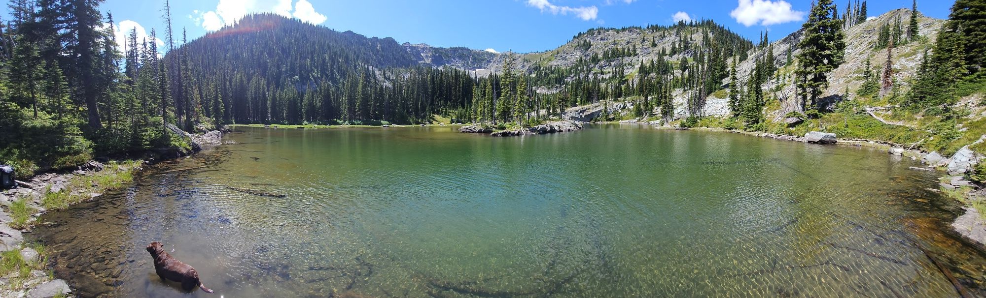
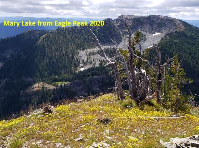
At the Lake: Mary Lake has no fish, and the only established campsites that I have seen is over by the very buggy outlet, but there might be a place or two above the lake along the 2 small inlet streams. I really liked this lake as you get some unique views of both Eagle and Ward Peaks, but you also get some outstanding views looking directly down into Hub Lake and Hazel Lake out in the distance. It is well worth the effort to visit Mary Lake.
Follow the same route out that you took to get to Mary Lake but do take the time to go to the top of Ward Peak, either on your way in or out of Mary Lake. The peak is one of the tallest for this area of the state line and has some very good views. There are remnants of the lookout tower (cabin) that sat there years ago. You can also take the primitive trail from Mary Lake to trail 280, then up 280 to trail #250 and back to the Ward Peak Trailhead.
Starting at Mary Lake the trail (see picture in gallery) can be found thus: Head directly over toward the ridge overlooking Hub Lake, angle a bit to the right where there is a break in the rock and the trail starts there and is well defined but un-marked. The trail is not too difficult to navigate as it is fairly visible most of the way, but at times brushy. There are several short sections of swampy / boggy areas along the way. Don't overthink these as the trail picks up again directly across the areas, just go straight across the wet areas as best you can. There is a good spring about halfway across the traverse that has enough volume to filter.