
Getting There: Exit I-90 at St Regis, turn right at the 4-way stop and cross both the St Regis River and Clark Fork River on this frontage road. After crossing the Clark Fork River, take an immediate left on Mill Creek Road. Mill Cr Rd will eventually turn into Southside Cutoff Rd. Follow this road for 3.3 miles; stay right at the junction and go through the gate.
 The gate should be open but if not then you may have to start there. Continue on this road for a little more than 1.5 miles to a signed trailhead at a generous wide spot on the road where River Trail #223 takes off.
On the Trail: Trail #223 starts out paralleling the river for about a mile until you cross under the powerlines and climb past the rockslide. From there the trail stays level and meanders through the trees. The trail climbs moderately after a couple miles and then drops back down and stays flat for another mile. You are on a very old logging road, and it is easy going with several small stream crossing along the way.
At about the 5-mile mark, the trail then climbs up along a steep slope for about 3/4 mile before dropping back down to the river. On the way look for a spring that comes out of a depression in the hillside.  This is an old mine that has caved in. Look for a couple sets of small rails from the mine along the trail. From the river the trail then slowly climbs up away from the river with several rollers along the way.
 There is no available water between there and almost the end at the Ferry Landing or about 1/2 mile onto the new Falls Flat trail. As you near the Peninsula CG on the opposite side of the river you will pass through 2 rather steep and deeper draws.
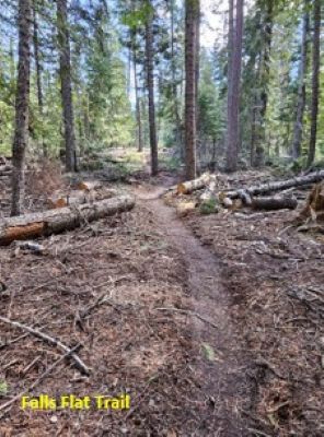
As you gain the ridge top from the second draw and start going down the gentle ridge to the Ferry Landing Trailhead, look for a trail that heads in the reverse direction and gently up the hill. This is the new Falls Flat trail to the Cascade Creek Falls and Campground on the Cutoff Road (Hwy 135). As of April 2024, the trail is not signed (maybe flagged) but is complete all the way through.
If going to the Ferry Landing Trailhead, then continue down the ridge past the peninsula overlook and down through the draw and under the bridges to the finish. This is about a 9-mile hike or bike. We see lots of bikes on the trail. Please note that River Trail #223 is also open to motorcycles, but the Falls Flat trail is not.
Cascade Creek Falls Variation: If continuing to Cascade Falls and that trailhead, take the new Falls Flat trail. The trail gets much more defined in 100 feet. It is around 5 miles to the falls and 6.5 to the Cascade Creek Trailhead. There is a creek crossing in a 1/2 mile and some ponds at the 2.5-mile mark; otherwise, it is dry until the falls. The trail climbs moderately from River Trail #223 for less than a mile, crossing a creek and entering a nice open tree’d flat. 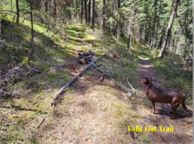 After the ponds and the overlook down to the Muchwater Campground the trail gets much harder. From the Muchwater overlook you can see the falls area and it looks tantalizingly close and easy, but it is deceiving. There are some steeper rollers and an unexpected set of switchbacks before you finally connect with the Iron Mtn Road #242 about 1/4 mile above the falls.
Once you connect with the Iron Mtn Road #242, head down 1/4 mile and hang a right to the Cascade Creek Falls and its overlooks. From the falls, head back to the main trail and down the hill to the campground in about 1.5 miles. From the St Regis trailhead it is almost 15 miles. If I were to complete the entire route, I would start at Cascade Creek as most of the hard hiking is completed in the first few miles.
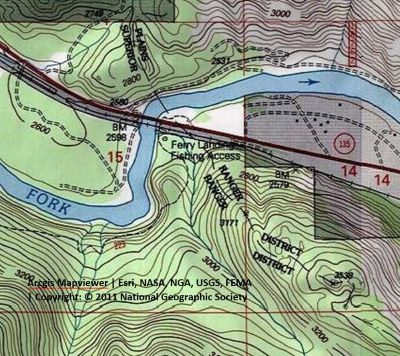
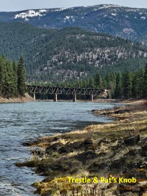
Getting There: Exit I-90 at St Regis, go straight through the 4-way stop and continue on the Cutoff Road (Hwy 135) until you cross the bridge at the 12.5-mile mark. Warning: be mindful of the speed limits as you leave or enter St Regis, or you have a good chance of getting a ticket. River Trail #223 leads underneath the highway and railroad bridges.
St. Regis Trailhead Destination: See the St. Regis Trailhead to Ferry Landing description and follow in reverse.

Cascade Creek Falls & Trailhead: River Trail #223 leads underneath the highway and railroad bridges and heads up a draw away from the river. The trail heads moderately uphill and climbs to a gentle ridge with an overlook of the Peninsula Campground. As you gain the ridge top from the overlook and start going down the hill into a deep draw, look for a trail that heads up and left from trail #223. This is the new Falls Flat trail to the Cascade Creek Falls and Campground on the Cutoff Road (hwy 135).
As of April 2024, the trail is not signed (maybe flagged) but is complete all the way through. The trail gets much more defined in 100 feet. It is around 6 miles to the falls and 7.5 miles to the Cascade Creek Trailhead. There is a creek crossing in 1.5 miles from the trailhead and some ponds at the 3.5-mile mark; otherwise, it is dry until the falls.
The trail climbs moderately from River Trail #223 for about 2 miles, crossing the creek and entering a nice open tree’d flat. After the ponds and the overlook down to the Muchwater Campground, the trail gets much harder.
From the Muchwater overlook, near the ponds, you can see the Cascade Creek Falls area and it looks tantalizingly close and easy, but it is deceiving. There are some steeper rollers and an unexpected set of switchbacks that gains more elevation before you finally connect with the old Iron Mtn Road #242 about 1/4 mile above the falls.
Once you connect with the Iron Mtn Road #242, head down 1/4 mile and hang a right to the Cascade Creek Falls and its overlooks. From the falls, head back to the main trail and down the hill to the campground in about 1.50 miles for a total of 7.5 miles. If you start at Cascade Creek, it is an easier hike as most of the hard hiking is completed in the first few miles.

Getting There: Exit I-90 at St. Regis, go straight through the 4-way stop and continue the Cutoff Road (Hwy 135) for about 16.25 miles. Warning: be mindful of the speed limits as you leave or enter St Regis, or you have a good chance of getting a ticket.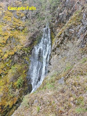 The trailhead is in the campground near the vault toilets. There is only parking for a couple vehicles.
St Regis Trailhead Destination: See the St. Regis Trailhead to Cascade Creek description and follow in reverse.
Ferry Landing Trailhead: See the Ferry Landing Trailhead to Cascade Creek description and follow in reverse.
Cascade Creek Falls & Iron Mtn Road: Trail #242 takes off near the vault toilets and climbs moderately for about 1.5 miles. There is a new trailhead next to the campground being built in 2025, but might not be fully complete until later in the summer. This can be a hot hike in the afternoon so be prepared. There is a sign for the falls on a tree, it is placed rather high but the trail to your left is obvious. The view looking north towards Quinn’s Hot Springs is very nice.
Iron Mtn Road: Back on the main trail #242 from the falls, the trail continues up at a moderate grade and a good path. In a 1/4 mile you will reach the new Falls Flat trail on a switchback that will lead to the other trailheads. Take the switchback and stay on trail #242.  This trail will continue to climb for another 3+ miles until you reach the Ninemile Divide Road #97 at over 6,000 feet. There are several creek crossings on the trail, but water is more scarce as you climb towards the divide. As kids we rode this trail on our motorcycles all the way to the campground and back. A full out to road #97 and back will be around 10 miles.
 Peninsula: 11.5 miles from St Regis on the right side before you cross the bridge. The turnoff is right on a corner so can be easy to miss. It has 10-12 sites of varying size and desirability and 1 vault toilet. There is no potable water or trash collection. There is a sign on the highway.