
Getting There: Take the Little Joe Road (#342) out of St. Regis and then take the stateline road (#391) north at the summit. The trailhead is about 8.5 miles from the Little Joe Road. The trailhead consists a small sign (trail# 269) just above the road, but the signage was gone in 2024.  There is a shallow turnout there, with a good spot to turn around a couple hundred yards down the road on a wide corner.
I have seen cars on this part of the road, but a higher clearance vehicle is preferable as once you go past the Square Lake trailhead the road gets much rougher. The trail takes off at the sign/post and angles up the hillside for a 1/4 mile before topping out and heading down the dividing ridge. The trail is in good shape, and it is an easy stroll to where the primitive trail takes off down the hill.
This primitive trail is at a low point on the ridge where the main trail is actually on the ridge about a mile from the road. Trail #269 then heads away from the ridgeline and goes around the hillside and eventually down to Crystal Lake 1.2 miles from the primitive trail.
The primitive trail heads steeply down the hill and across an open slope but peters out once you hit the trees, at least I could not find a trail. From there head down the hill following the path of least resistance. There are plenty of brush and deadfalls. I ended up following some small ridges that had less brush and deadfalls down to the inlet stream and clearing above the lake and then down from there.
 On the way out I went over by the little penninsula and climbed from there, hoping for a better route out. I didn’t find a trail until I got back to the primitive trail at the tree line. It was brushy and steep on the way out but ended up right where the primitive trail disappeared on the way down. It was still a hard climb through the brush.
 For the short distance it was a lot of work in and out of Rudie Lake. There is no water between the trailhead and the lake so plan accordingly, especially on the way out.
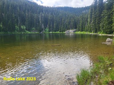
At the Lake: Rudie Lake is not very large. It is brushy and the immediate shoreline can be swampy on the west side, but you can work your way around the lake with a little bit of effort as there is a rough trail around most of the lake. I found 2 campsites while I was there, one on the small peninsula and one on the large prominent rock on the southern end of the lake. The campsite near the peninsula doesn’t look like it has been used in a while.
The other campsite by the inlet is on a large flat rock, there is enough room for 2 or 3 tents, although any tent should be free-standing. This campsite looks to have been used in the past couple of years as there are some fresh cut logs around the fire ring.
Brook Trout populate the lake, and they were very active when I was there in 2023. I got a strike on my lure 8 of 10 casts. The brookies weren’t much for size, about 8-10 inches, but there were lots of them.
Alternate Route: You can also get to Rudie Lake from Crystal Lake. Trail #269 to Crystal Lake continues up the hill past Crystal and will end at state line road #391, 2.25 miles from Crystal Lake. You would take the same primitive trail down to Rudie Lake. This option shortens the driving time by coming up Deer Creek but doubles the hiking distance.


