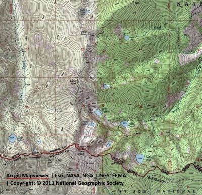
Getting There: The best route to get to the trailhead is to take the Little Joe Road (#282) out of St. Regis and then take the state line road (#391) north at the Idaho / Montana summit. Follow this road for approximately 5.5 miles. The trailhead is about a mile past the Square Lake trailhead. The trailhead for trail #250 is on the shoulder of Ward Peak and has signage (maybe gone). There is a wide spot just back from that point or you can park at another pullout just down the road. There is another road from the Idaho side that connects just down from there to turn around. The state line road (#391) gets considerably narrower and rougher at that point.  Take the Ward Peak trail (#250) straight up the hill from the road. The trail is obvious as there has been motorized traffic up the first 100 yards or so in the past. At about the 1/2-mile mark there will be a primitive trail to the left that heads back down towards the road; stay right. Not long after there is another split; stay to the right (upper) at the split. The lower trail (#250) is the Up Up Mountain ridge trail that will take you down to the intersection of trail #280 coming out of Ward Creek, over to Eagle and Gold peaks and eventually to the road to Up Up Lookout.
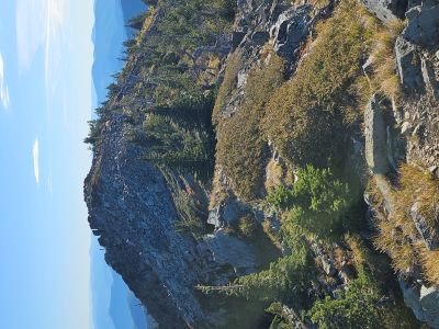
The upper trail is not numbered and will take you to the summit of Ward Peak. The upper trail climbs moderately up to the ridge line that overlooks Mary Lake, and the Ward Creek drainage. The trail then switchbacks up the ridge to the summit of Ward Peak; a total of 1.3 miles. Ward Peak is one of the easiest summits of the named peaks over 7,000 feet along the state line in the Great Burn region. The easiest is Schley Mountain with a hike of 0.75 miles and just 600 vertical feet. I do not include Little Joe Mountain as its summit is drivable. 
Getting There:  Take the Ward Creek Road (#889) exit off I-90. The exit is only accessible from the East bound lanes and sits right on a sharp corner, if not paying attention you could miss it. Drive (~6 miles) to a switchback and bridge across Ward Creek where there is a sign for the trailhead and ample parking. Stay on the main road, you will pass the road that leads to Up Up Lookout at mile 3. The lookout is rentable, but not recommended for small children for safety reasons.
Trail (#262) starts out meandering through the bottoms and some cedar groves. The trail climbs moderately and after a mile or so you will get to a nice set of waterfalls far below the trail. It is a steep climb down but well worth it. The trail splits just past the falls with trail #262 turning left steeply up the hill and back towards the state line; there is (was) a sign at the intersection. This is not a shortcut to Hazel Lake, nor does it go to Square Lake. Rather it ends up on the state line road (#391) about 1/4 mile from the Square Lake trailhead. You can see portions of it along the hillside across the valley if you look closely.
 Continue straight on trail #280 that heads back along the hillside to a couple of switchbacks before the trail lines out for Hazel Lake. The trail has plenty of water for your dog, so no need to carry extra. Hazel Lake is about 3 miles from the trailhead. From Hazel Lake continue up the main trail. It is less than a mile up to Hub Lake with an elevation gain of less than 400 feet. The trail takes a sharp dip for a couple hundred yards to cross the Hub Lake outlet creek and then immediately goes back up and then quickly arrives at the lake.
Continue around the right side of Hub Lake for the tough climb up to the saddle between Ward and Eagle Peaks. It is less than a mile, but it is a steep and rocky trail. Don’t forget to walk over to the old mine opening that is a couple hundred feet up the hill from Hub Lake.  Once at the saddle where trail #280 intersects with trail #250 turn left and head up towards Ward Peak. You are still over 700 vertical feet from the summit, so it is a bit of a slog after climbing up from Hub Lake. Follow trail #250 until you intersect with the trail that head back up to the ridgeline on Ward Peak. The upper trail climbs moderately up to the ridge line that overlooks Mary Lake, and the Ward Creek drainage. The trail then switchbacks up the ridge to the summit of Ward Peak. This is a tough route.
On the Summit: The summit has a USGS Survey marker and the remnants of the long-gone lookout cabin. An original cabin was built in 1914, replaced by an L-2 cupola cabin in 1929 (pictured below) and eventually destroyed in the 1950's. The views in all directions are outstanding with Eagle Peak and the basin containing Mary Lake dominates the view to the North. You can also see the top of Gold Peak peaking just over the right shoulder of Eagle Peak.
Bonus Route – Climb Ward, Eagle & Gold Peaks: It is possible to make all three summits along Trail #250 in a day. Start at State Line Road #391 trailhead, climb Ward Peak first, then Eagle and Gold. You end up climbing Eagle Peak twice but coming back from Gold Peak the elevation gain is half of that coming from Ward Peak. This is the easiest route from the 3 trailheads in the area. The only bad aspect is that there is no water along this route outside of possible snowbanks. You could go to the small stream below Gold Peak, but that is almost 400 feet down and a mile round trip. There may be a small stream below the Eagle/Ward saddle, but I cannot confirm that. This is a 10-mile round trip with lots of vertical, so not a cakewalk. The trails are very well defined and in good condition.