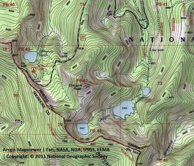
Getting There: From Superior, take Cedar Creek Road #320 and head toward Missoula Lake and Cascade Pass, 25 miles; stay on the main road as there are several other roads that connect. After coming off Miller Saddle, (about 20 mi) there will be an intersection at the bottom of the drainage.
Take the left fork to the Oregon Lakes trailhead (1/2 mi); the right fork heads down to the Big Flat; going straight will take you across Oregon Creek up to the state line and Missoula Lake. There is adequate signage at the intersection. The parking at the trailhead is not very big, maybe 5-6 vehicles. Trail #109 takes off at that point and climbs steadily and sometimes steeply for about a 1/2 mile to the lower lake. Follow the trail around the right side of the lower lake and up the hill to the Middle Oregon, it is less than a 1/2 mile further.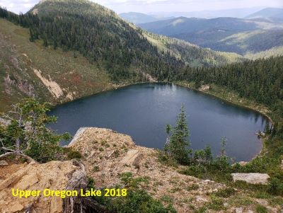 Head around the right side of the lake on the shoreline trail to the inlet creek coming from Upper Oregon Lake. There is no trail from the Middle to Upper Oregon Lake. It is a steep bushwack up the hill and back. This is the challenger designation for getting to the upper lake from the middle lake.

Getting There: I prefer this option as it is the easiest and shortest route to Upper Oregon Lake. From Superior, take Cedar Creek Road #320 and head toward Missoula Lake and Cascade Pass, 25 miles; stay on the main road as there are several other roads that connect. After coming off Miller Saddle, (about 20 mi) there will be an intersection at the bottom of the drainage. Stay straight crossing Oregon Creek. The right fork at this intersection (road #7763) heads down the hill to the Big Flat; the left fork will take you up to the Oregon Lakes trailhead (1/2 mi).
About a mile from the stateline (Cascade Pass) there will be a road dropping off to the right and signage for Missoula Lake and campground. Go past this turnoff for about 2 tenths of a mile where there is a wide spot on the right to park; also at this point is a trail coming out of the Missoula Lake Campground. There is a marginal unmarked trail starting directly across from this point near a small stream that will wind its way through the scrub trees and eventually makes a steep climb up over the saddle and down to the lake. Once you cross the small stream about halfway up the basin the trail becomes much better. Take care with your route finding as there are several other false trails that can be followed but do not lead anywhere. The trail gets more defined as you get farther up the hillside from the road. It is less than a mile to the lake from the road.

Getting There: Another route is to start at Cascade Pass (Missoula Lake Saddle) and head south on the state line trail towards Illinois Peak. From Superior, take Cedar Creek Road #320 and head toward Missoula Lake and Cascade Pass, 25 miles; stay on the main road as there are several other roads that connect. After coming off Miller Saddle, (about 20 mi) there will be an intersection at the bottom of the drainage. Stay straight crossing Oregon Creek. The right fork at this intersection (road #7763) heads down the hill to the Big Flat; the left fork will take you up to the Oregon Lakes trailhead (1/2 mi). Continue past Missoula Lake to Cascade Pass (Missoula Lake saddle) and take the stateline trail #738 south towards the Illinois Peak. When you get back to the stateline and overlooking the Upper Oregon Lake, leave the trail and work your way back north along the ridge to connect with an obvious trail that traverses the hillside towards Oregon Peak and connects into the trail from Missoula Lake just below the low saddle.
The primitive trail is not great but offers an alternative to the other routes. You could also use this route as part of loop from the Missoula Lake route. This route is about twice as far as the route over the low saddle from Missoula Lake.
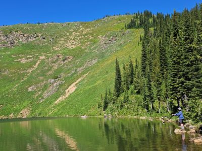
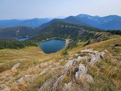
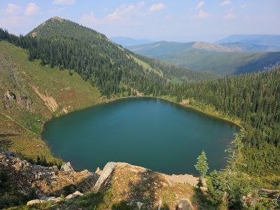
At the Lake: The fishing can be outstanding with Brook Trout taking anything that moves, and the shoreline is walkable around the entire lake, but a bit steep on the far side. There is one campsite directly on the other side of the outlet that can accommodate several tents. There is another site farther to the left towards the little cove area that sits above the lake.
This is the first place that I camped overnight without adults; I did a trip to Trail Lake with the Boy Scouts the previous summer. My parents dropped my brother, 2 of his friends and myself off on Freezeout Pass with the intent to pick us up in Dry Creek several days later. We climbed up Illinois Peak on the ridge trail and spent our first night here before moving on to the Bonanza Lakes. The weather went bad at the Bonanza Lakes, and we bailed and went down Bonanza Gulch all the way to the dredge on Lost Creek where we caught a ride home. We were 14-15 years old at the time.