Getting There: Take the Hiawatha Bike Trail exit off I-90; then the right fork that goes over the state line to Rowland. If you end up in the Hiawatha parking lot, then you missed it.  A mile or so up that road take the left fork and you will connect to the state line road (#391) in about 1.25 miles.
Take the left fork up the hill and follow this road for a bit more than 5 miles. You will pass by the road (#305) that goes to Silver Lake from Saltese at about the 5-mile mark. I don’t go via Saltese due to the road being so rough and rocky. There will be a side road (jeep trail) about a quarter mile from that junction that angles up to the left; there is no signage. If you have a pickup and want to beat it up a bit more then go right ahead. Otherwise, there is a small wide spot to park at that point or park back at the junction of roads #305 and #391.
Follow the jeep trail up to the top of the hill (1/4 mi); there is a fire pit and camping site there that is well used. Keep following the trail/road down to a rock outcropping that provides an excellent view of the lake and surrounding area. There are 3 metal memorials attached to the rock. The jeep trail ends at this point and trail #255 continues down to the right on the prominent ridge.
 Follow the trail until you get into the trees and come to a flat area; hang a hard right off the trail and head straight down the hill. Stay to the right of the shallow draw and wander the path of least resistance until you arrive at the lake. This is not very far, maybe a 1/4 mile.
  Too far left and you risk missing the lake, too far right and you end up in the swampy inlet stream area.
NOTE: Topographic maps show an un-numbered trail that starts about 3/4 mile south along road #391 at a low saddle that goes directly to the lake. I tried to find this trail from both the saddle and lake, but it didn't seem to exist anymore. I may try again in the future
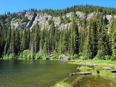
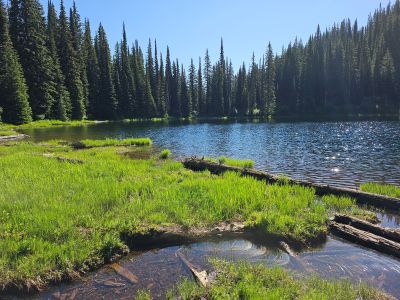
At the Lake: There is one established campsite on the northern shore and another possibility on the western end just off the big rock. I have done well fishing here for Cutthroats, but it wouldn’t take too much pressure for the lake to be fished out. It is not a big lake and is only stocked every 7 years. I only make 1 trip a year into the lake for those reasons. The southwest corner of the lake is a little brushy but you can find good spots along the shore to cast.
There is no water between the lake and your vehicle coming out along the open hillside can be hot in the afternoon. There is no name for the lake on any Forest Service maps or Google Earth, but stocking reports have Tadpole Lake as the official name. Locally, it is called No Name Lake. When you leave just head back up the hill from the campsite along the north shoreline. Make sure you have bug spray as there are lots of mosquitoes.